Jupiter in Palm Beach County, Florida — The American South (South Atlantic)
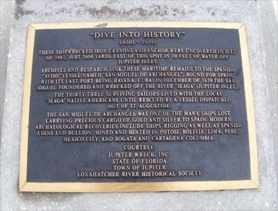
"Dive Into History"
(Año - 1659)
Archives and research link these maritime remains to the Spanish "Aviso" vessel named "San Miguel de Archangel", bound for Spain, with its last port being Havana, Cuba. In December of 1659 the San Miguel foundered and wrecked off the river "Jeaga" (Jupiter Inlet).
The thirty-three surviving sailors lived with the local "Jeaga" native Americans until rescued by a vessel dispatched out of St. Augustine.
The San Miguel de Archangel was one of the many ships lost carrying precious cargo of gold and silver to Spain. Modern archaeological recoveries include ships' rigging as well as Spanish coins and bullion, mined and minted in Potosi, Bolivia; Lima, Peru; Mexico City; and Bogata and Cartagena Columbia.
Erected by Jupiter Wreck, Inc., State of Florida, Town of Jupiter, Loxahatchee River Historical Society.
Topics. This historical marker is listed in these topic lists: Disasters • Native Americans • Settlements & Settlers • Waterways & Vessels. A significant historical month for this entry is July 1987.
Location. 26° 57.017′ N, 80° 5.084′ W. Marker is in Jupiter, Florida , in Palm Beach County. Marker is on Captain Armour's Way, 0.1 miles south of South Beach Road (County Road 707), on the left. Marker is located in Jupiter Lighthouse Park. Touch for map. Marker is at or near this postal address: 500 Captain Armour's Way, Jupiter FL 33469, United States of America. Touch for directions.
Other nearby markers. At least 8 other markers are within walking distance of this marker. World War II U.S. Naval Housing Building (about 700 feet away, measured in a direct line); Seminoles and Pioneers (about 700 feet away); A People By The Sea (about 700 feet away); Unconquered Legacy (about 700 feet away); Jupiter Lighthouse (approx. 0.2 miles away); Jupiter Lighthouse Museum (approx. 0.2 miles away); Jupiter Inlet Lighthouse began protecting ships at sea on July 10, 1860 (approx. 0.2 miles away); Ft. Jupiter - Jupiter Lighthouse (approx. half a mile away). Touch for a list and map of all markers in Jupiter.
Credits. This page was last revised on March 4, 2018. It was originally submitted on May 17, 2015, by James R. Murray of Elkton, Florida. This page has been viewed 650 times since then and 16 times this year. Photos: 1, 2, 3. submitted on May 17, 2015, by James R. Murray of Elkton, Florida. • Bernard Fisher was the editor who published this page.


