Selma in Dallas County, Alabama — The American South (East South Central)
Redoubt No. 24
Selma Fortifications 1863-1865
— Battle of Selma —
Side 1
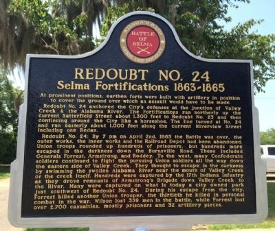
At prominent positions, earthen forts were built with artillery in position to cover the ground over which an assault would have to be made.
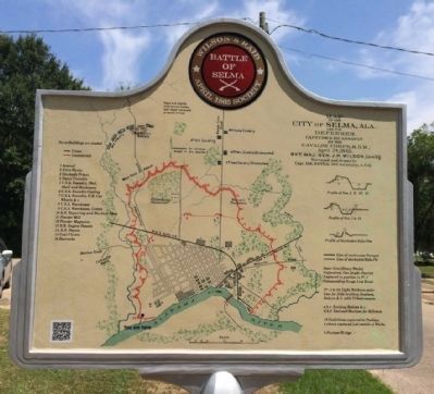
Redoubt No. 24 anchored the City's defenses at the junction of Valley Creek & the Alabama River. The Fortifications ran northerly up the current Satterfield Street about 1,300 feet to Redoubt No. 23 and then continuing around the City like a horseshoe. The line turned at No. 24 and ran easterly about 1,000 feet along the current Riverview Street including one Redan.
Redoubt No. 24: By 7 pm on April 2nd, 1865 the Battle was over, the outer works, the inner works and the Railroad Depot had been abandoned. Union troops rounded up hundreds of prisoners, but hundreds more escaped in the darkness down the Burnsville Road. These included Generals Forrest, Armstrong, and Roddey. To the west, many Confederate soldiers continued to fight the pursuing Union soldiers all the way down the eastern side of Valley Creek. They thought to escape in the darkness by swimming the swollen Alabama River near the mouth of Valley Creek or the Creek itself. Hundreds were captured by the 17th Indiana Infantry as they drove remnants of Armstrong's Brigade down Valley Creek to the River. Many were captured on what is today a City owned park just southwest of Redoubt No. 24. During his escape from the city, Forrest killed another Union trooper, the thirtieth he killed in personal combat in the war. Wilson lost 359 men in the battle, while Forrest lost over 2,700 casualties, mostly prisoners and 32 artillery pieces.
Side 2
A Map of the City of Selma, Ala. and its defenses (April 2nd, 1865).
Erected 2014 by The April 1865 Society.
Topics. This historical marker is listed in these topic lists: War, US Civil • Waterways & Vessels. A significant historical month for this entry is April 1850.
Location. 32° 24.067′ N, 87° 2.061′ W. Marker is in Selma, Alabama, in Dallas County. Marker is at the intersection of Satterfield Street and Riverview Avenue, on the right when traveling south on Satterfield Street. Touch for map. Marker is at or near this postal address: 1 Satterfield Street, Selma AL 36701, United States of America. Touch for directions.
Other nearby markers. At least 8 other markers are within walking distance of this marker. Lt. Gen. Nathan Bedford Forrest Monument (approx. 0.3 miles away); Live Oak Cemetery (approx. 0.3 miles away); William Rufus de Vane King (approx. 0.3 miles away); Dallas County Korean War Memorial (approx. half a mile away); Dallas County World Wars Memorial (approx. half a mile away); Memorial Stadium (approx. half a mile away); Take Her Down (approx. half a mile away); Dallas County Vietnam Memorial (approx. half a mile away). Touch for a list and map of all markers in Selma.
More about this marker. One of a newer interactive marker that includes QR codes that allow you to use your smartphone to see additional photos and stories.
Also see . . . The Battle of Selma. (Submitted on July 30, 2014, by Mark Hilton of Montgomery, Alabama.)
Credits. This page was last revised on January 5, 2018. It was originally submitted on July 30, 2014, by Mark Hilton of Montgomery, Alabama. This page has been viewed 928 times since then and 38 times this year. Last updated on May 22, 2015, by J. Makali Bruton of Accra, Ghana. Photos: 1, 2, 3, 4, 5. submitted on July 30, 2014, by Mark Hilton of Montgomery, Alabama.
