Tamarac National Wildlife Refuge in Becker County, Minnesota — The American Midwest (Upper Plains)
Old Government Road
Photographed by D. Bjorn, June 14, 2007
1. Old Government Road Marker
Inscription.
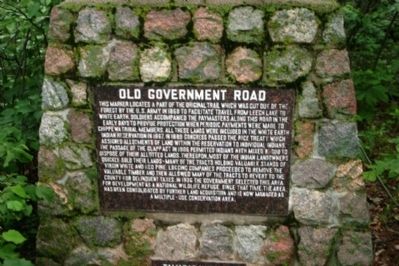
Old Government Road. . This marker locates a part of the original trail which was cut out of the forest by the U.S. Army in 1868 to facilitate travel from Leech Lake to White Earth. Soldiers accompanied the paymasters along this road in the early days to provide protection when periodic payments were made to Chippewa tribal members. All these lands were included in the White Earth Indian Reservation in 1867. In 1889 Congress passed the Rice Treaty which assigned allotments of land within the reservation to individual Indians. The passage of the Clapp Act in 1906 permitted Indians with mixed blood to dispose of their allotted lands. Thereupon, most of the Indian landowners quickly sold their lands - many of the tracts holding valuable stands of virgin white and red pine. Logging companies proceeded to remove the valuable timber and then allowed many of the tracts to revert to the county for delinquent taxes. In 1936 the government selected this area for development as a national wildlife refuge. Since that time, the area has been consolidated by further land acquisition and is now managed as a multiple-use conservation area.
This marker locates a part of the original trail which was cut out of the forest by the U.S. Army in 1868 to facilitate travel from Leech Lake to White Earth. Soldiers accompanied the paymasters along this road in the early days to provide protection when periodic payments were made to Chippewa tribal members. All these lands were included in the White Earth Indian Reservation in 1867. In 1889 Congress passed the Rice Treaty which assigned allotments of land within the reservation to individual Indians. The passage of the Clapp Act in 1906 permitted Indians with mixed blood to dispose of their allotted lands. Thereupon, most of the Indian landowners quickly sold their lands - many of the tracts holding valuable stands of virgin white and red pine. Logging companies proceeded to remove the valuable timber and then allowed many of the tracts to revert to the county for delinquent taxes. In 1936 the government selected this area for development as a national wildlife refuge. Since that time, the area has been consolidated by further land acquisition and is now managed as a multiple-use conservation area.
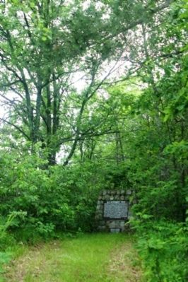
Location. 47° 1.417′ N, 95° 36.817′ W. Marker is in Tamarac National Wildlife Refuge, Minnesota, in Becker County. It is on County Route 143 0.7 miles west of Egg Lake Trail. Touch for map. Marker is in this post office area: Detroit Lakes MN 56501, United States of America. Touch for directions.

Regionally, this marker is in the American Midwest and in the Corn Belt. Globally, it is in North America, the Western Hemisphere, the Western World, and the Anglosphere. Historically, it finds itself in what was once Ruperts Land, the territory of the Mississippian Culture, and the Louisiana Purchase.
Other nearby markers. At least one other marker is within 7 miles of this marker, measured as the crow flies: Old Indian Trail (approx. 6.2 miles away).
Also see . . . 1. Tamarac National Wildlife Refuge. The marker is located near Egg Lake, in the Tamarac National Wildlife Refuge. (Submitted on June 25, 2008, by Kevin W. of Stafford, Virginia.)
Wikipedia entry (Submitted on September 5, 2025, by Larry Gertner of New York, New York.)
Credits. This page was last revised on September 5, 2025. It was originally submitted on June 25, 2008, by Kevin W. of Stafford, Virginia. This page has been viewed 3,001 times since then and 53 times this year. Photos:1, 2. submitted on June 25, 2008, by Kevin W. of Stafford, Virginia.
