Near Guernsey in Platte County, Wyoming — The American West (Mountains)
The United States Army and the Oregon Trail
Inscription.
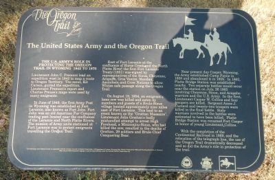
Lieutenant John C. Fremont led an expedition west in 1842 to map a route to Oregon Territory. The scout, Kit Carson, guided the expedition. Lieutenant Fremontís report and Charles Preussís maps were used by many emigrants.
In June of 1849, the First Army post in Wyoming was established at Fort Laramie, also known as Fort John. Fort John was an old American Fur Company trading post located near the confluence of the Laramie and North Platte Rivers. The mission of Army units stationed at Fort Laramie was to protect emigrants travelling the Oregon Trail.
East of Fort Laramie at the confluence of Horse Creek and the North Platte River, the first Fort Laramie Treaty (1851) was signed by representatives of the Sioux, Cheyenne, Arapaho, Gros Ventre, Mandan, Assiniboin, and Crow Nations to allow whites safe passage along the Oregon Trail.
On August 19, 1854, an emigrantís lame cow was killed and eaten by members and guests of a Brule-Sioux village located approximately nine miles east of Fort Laramie. This led to an event known as the “Grattan Massacre”. Lieutenant John Grattanís badly mishandled attempt to arrest High Forehead, a Miniconjou-Sioux, who had killed the cow, resulted in the deaths of Grattan, 29 soldiers, and Brule Chief Conquering Bear.
Near present-day Casper, Wyoming, the Army established Camp Payne in 1858 and abandoned it in 1859. In 1862, Platte Bridge Station was established nearby. Two separate battles would occur near the station on July 26, 1865 involving Cheyenne, Sioux, and Arapaho warriors and the US Army. In the first, Lieutenant Caspar W. Collins and four troopers were killed. Sergeant Amos J. Custard and twenty-two troopers were killed in the final battle. Sixty warriors involved in the battles were estimated to have been killed. Platte Bridge Station was renamed Fort Casper in honor of young Lieutenant Collins.
With the completion of the Continental Railroad in 1869, and the relocation of the telegraph line, the use of the Oregon Trail dramatically decreased and so did the Armyís role in protecting the trail.
Erected by The Wyoming National Guard, in cooperation with the Advisory Council on Historic Preservation, U.S. Department of the Interior, Wyoming State Historic Preservation Office, ad Wyoming State Parks and Historic Sites.
Topics and series. This historical marker is listed in these topic lists: Forts and Castles • Roads & Vehicles • Wars, US Indian. In addition, it is included in the Oregon Trail series list. A significant historical month for this entry is June 1849.
Location.
42° 15.413′ N, 104° 44.937′ W. Marker is near Guernsey, Wyoming, in Platte County. Marker can be reached from Lucinda Rollins Road near South Guernsey Road, on the left when traveling west. Touch for map. Marker is in this post office area: Guernsey WY 82214, United States of America. Touch for directions.
Other nearby markers. At least 8 other markers are within walking distance of this marker. Forts, Stations, and Camps (a few steps from this marker); Oregon Trail Ruts (a few steps from this marker); Oregon Trail Ruts State Historic Site (a few steps from this marker); The US Armyís Role in Protecting the Oregon Trail is Best Described by the Soldiers (within shouting distance of this marker); a different marker also named Oregon Trail Ruts (about 400 feet away, measured in a direct line); Encampments in the Guernsey Area (about 400 feet away); Grave of Lucindy Rollins (approx. 0.3 miles away); Laramie Peak (approx. 0.9 miles away). Touch for a list and map of all markers in Guernsey.
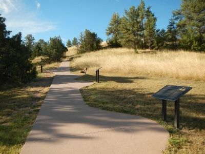
More about this marker. This marker is located in Oregon Trail Ruts State Historic Site on the path leading from the parking lot to the Oregon Trail Ruts.
Credits. This page was last revised on June 14, 2020. It was originally submitted on July 19, 2015, by Barry Swackhamer of Brentwood, California. This page has been viewed 559 times since then and 59 times this year. Photos: 1, 2, 3. submitted on July 19, 2015, by Barry Swackhamer of Brentwood, California. • Andrew Ruppenstein was the editor who published this page.


