Fredericksburg, Virginia — The American South (Mid-Atlantic)
Willis Hill Cemetery
The Battle of Fredericksburg
| — | Fredericksburg and Spotsylvania National Military Park | — |
Photographed by Craig Swain, May 25, 2008
1. Willis Hill Cemetery Marker
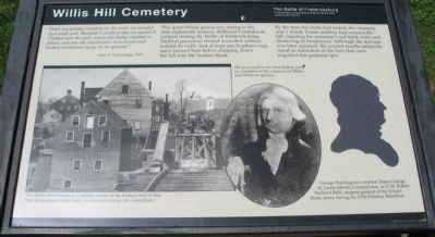
"There is a private cemetery on the crest, surrounded by a brick wall. Burnside's artillery had not spared it. I looked over the wall, which was badly smashed in places, and saw the overthrown monuments and broken tombstones lying on the ground."
John T. Trowbridge, 1865
This quiet hilltop graveyard, dating to the mid-eighteenth century, sheltered Confederate soldiers during the Battle of Fredericksburg. Medical personnel treated wounded soldiers behind its walls, and at least one Southern regiment paused here before charging down the hill into the Sunken Road.
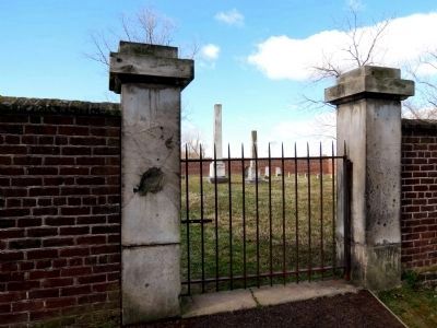
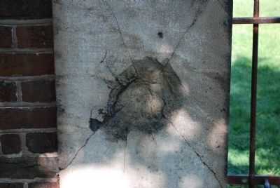
By the time the battle had ended, the cemetery was a wreck. Union artillery had scoured the hill, toppling the cemetery's red brick walls and shattering its headstones. Although the damage was later repaired, the scarred marble gateposts stand as reminders of the fury that once engulfed this peaceful spot.
Erected by National Park Service, U.S. Department of the Interior.
Topics. This historical marker is listed in these topic lists: Cemeteries & Burial Sites • War, US Civil. A significant historical year for this entry is 1865.
Location. 38° 17.635′ N, 77° 28.139′ W.
this page online

Regionally, this marker is in the Washington Metropolitan Area and in Northern Virginia. It is also in the American South and specifically in the Upper South. Globally, it is in North America, the Western Hemisphere, the Western World, and the Anglosphere. Historically, it finds itself in what was once the territory of the Mississippian Culture, one of the original Thirteen Colonies, one of the Confederate States of America, and the Antebellum South.
Other nearby markers. At least 8 other markers are within walking distance of this marker: Fredericksburg National Cemetery (within shouting distance of this marker); Battered Buildings on Willis Hill (within shouting distance of this marker);
Photographed by Craig Swain, May 25, 2008
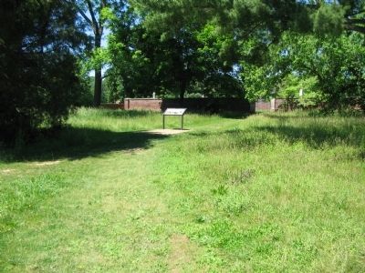
2. Willis Hill Cemetery Marker
Other markers no longer nearby. The Willis Hill Buildings (was about 300 feet away, measured in a direct line but has been replaced with another marker now near it); Fredericksburg Campaign (was about 400 feet away but has been confirmed missing); a different marker also named Fredericksburg Campaign (was about 400 feet away but has been permanently removed).
More about this marker. On the left side of the marker The Willis Hill Cemetery is faintly visible in the background of this 1863 photograph taken from the Fredericksburg city waterfront. A black arrow indicates the location of the Willis Cemetery in the photo. The graveyard is the final resting place for members of the Carmichael, Willis, and Wellford families.

Photographed by Craig Swain, May 25, 2008
3. The Cemetery
Photo taken through the front gate of the cemetery.
Also see . . . Marye's Heights Virtual Tour. National Park Service page. (Submitted on July 2, 2008, by Craig Swain of Leesburg, Virginia.)
Photographed by Roger Reus, February 25, 2012
4. Willis Hill Cemetery Marble Gateposts
The marble gateposts at the entrance to the cemetery still show several dozen bullet holes and one clear cannonball strike.
Photographed by Brandon Fletcher, July 19, 2008
5. Willis Hill Cemetery Marker
Close up of post struck by cannon ball
Credits. This page was last revised on February 2, 2023. It was originally submitted on July 2, 2008, by Craig Swain of Leesburg, Virginia. This page has been viewed 3,471 times since then and 110 times this year. Photos: 1, 2, 3. submitted on July 2, 2008, by Craig Swain of Leesburg, Virginia. 4. submitted on February 26, 2012, by Roger Reus of Richmond, Virginia. 5. submitted on July 26, 2015, by Brandon Fletcher of Chattanooga, Tennessee.
