
Metapán, Santa Ana, El Salvador — Central America (West Coast)
Municipality of Metapán
La Municipalidad de Metapán
Photographed by J. Makali Bruton, August 24, 2015
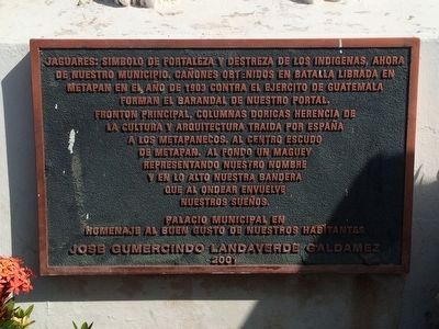
1. Municipality of Metapán Marker

Fronton principal, columnas dórica herencia de la cultura y arquitectura traída por España a los metapanecos. Al fondo un maguey representando nuestro nombre y en lo alto nuestra bandera que al ondear envuelve nuestros sueños.
Palacio Municipal en homenaje al buen gusto de nuestros habitantes
Jose Gumercindo Landaverde Galdamez
2001
Jaguars: Symbol of the strength and ability of the native people that now represent our municipality. The rifle barrels obtained in a battle that took place in Metapán in 1903 against the army of Guatemala now form the fence of our entryway. The entryway includes Doric columns that are the legacy of the culture and architecture brought from Spain to the people of Metapán. At the center, the seal of Metapán, with a maguey plant as a background representing our name and flying high, our flag that by waving captures our dreams.
Municipal Palace in tribute
this page online
Jose Gumercindo Landaverde Galdamez
2001
Erected 2001 by Municipalidad de Metapán.
Topics. This historical marker is listed in these topic lists: Colonial Era • Settlements & Settlers • Wars, Non-US. A significant historical year for this entry is 1903.
Location. 14° 19.907′ N, 89° 26.878′ W. Marker is in Metapán, Santa Ana. It is on 1a Calle Poniente. The marker is in front of the Municipal Palace of Metapán, on Avenida Benjamín Estrada Valiente. Touch for map. Touch for directions.

Regionally, it is in North America, specifically in Central America, in Mesoamerica, on the Ring of Fire, on the Pacific Rim, and in the Western Hemisphere. Historically, it finds itself in what was once New Spain and also a Spanish colony.
Other nearby markers. At least 3 other markers are within walking distance of this marker: Bicentennial of the First Cry of Central American Independence (here, next to this marker); Centennial of Salvadoran Independence (within shouting distance of this marker); Saint Peter Church of Metapán (within shouting distance of this marker).
Photographed by J. Makali Bruton, August 24, 2015
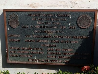
2. Municipality of Metapán additional marker
This marker mentions that the Municipal Palace was renovated during José Gumercindo Landaverde Galdámez's administration of 2000-2003. This marker is found on the left-most jaguar statue facing the Municipality.

Photographed by J. Makali Bruton, August 24, 2015
3. Municipality of Metapán additional marker
This decorative stone engraving is supposedly original to the Municipal Palace and reads, "Metapam Plaza de la Constitucion publicada el dia siete de noviembre de 1812", (Metapam Plaza of the Constitution of November 7, 1812). This refers to the Spanish Constitution of 1812.
Photographed by J. Makali Bruton, August 24, 2015
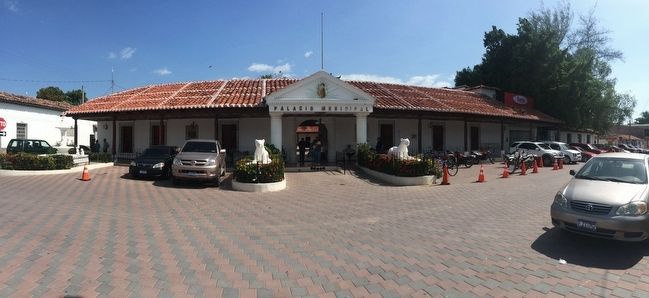
4. Municipality of Metapán Marker
An overall view of the Municipality of Metapán and its various markers. Note the doric columns and maguey plant (above the entryway) mentioned in the marker. Metapán means "River of magueyes" in Nahuat.

Photographed by J. Makali Bruton, August 24, 2015
5. Guatemalan rifle barrels as a fence around the jaguar statue.
The rifle barrels are mentioned in the marker text. These were captured during the 1903 "Guerra de los Totopostes" (The Corncake War, so named because of the food sent to soldiers stationed along the Guatemala-El Salvador border).
Credits. This page was last revised on May 10, 2023. It was originally submitted on September 24, 2015, by J. Makali Bruton of Washington, District of Columbia. This page has been viewed 584 times since then and 39 times this year. Photos: 1, 2, 3, 4, 5. submitted on September 24, 2015, by J. Makali Bruton of Washington, District of Columbia.
