Rocky Mountain National Park in Larimer County, Colorado — The American Mountains (Southwest)
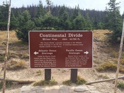
Continental Divide
Milner Pass elev. 10,759 ft.
Inscription.
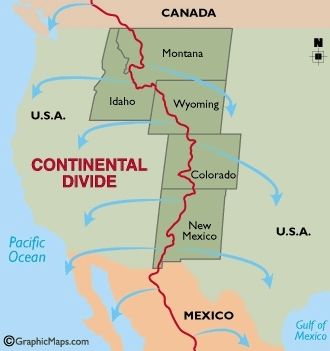
The "great divide" separates drainage to the Atlantic
from drainage to the Pacific. It traverses America from
Alaska almost to Cape Horn.
Atlantic Ocean
«« drainage
Cache La Poudre Creek
drains into the Platte River
which flows to the Missouri,
then to the Mississippi, thus
reaching the Gulf of Mexico.
(part of the Atlantic Ocean)
Pacific Ocean
drainage »»
Beaver Creek drains into
the Colorado RIver, which then
flows through Grand Canyon
National Park and on to the
Gulf of California. (A part
of the Pacific Ocean)
Erected by National Park Service.
Topics. This historical marker is listed in these topic lists: Natural Features • Waterways & Vessels.
Location. 40° 25.208′ N, 105° 48.696′ W. Marker is in Rocky Mountain National Park, Colorado, in Larimer County. Marker is on Trail Ridge Road (U.S. 34) 17.1 miles north of Western Road (County Road 49), on the right when traveling north. Located at the Milner Pass pullout. This is a seasonal park road and closed in winter. Call recorded line 970-586-1222 for status. Touch for map. Marker is at or near this postal address: 1043 Trail Ridge Road, Estes Park CO 80517, United States of America. Touch for directions.
Other nearby markers. At least 8 other markers are within 5 miles of this marker, measured as the crow flies. Gore Range (approx. 2.4 miles away); Old Fall River Road (approx. 3.4 miles away); People of Kawuneeche Valley (approx. 4 miles away); Never Summer Ranch (approx. 4 miles away); Moose (approx. 4.1 miles away); Trail Ridge Road at Rock Cut (approx. 4.2 miles away); Holzwarth Trout Lodge 1920-29 (approx. 4.2 miles away); Roger Wolcott Toll (approx. 4.6 miles away). Touch for a list and map of all markers in Rocky Mountain National Park.
Also see . . . Wikipedia article on Milner Pass. (Submitted on September 27, 2015, by Mark Hilton of Montgomery, Alabama.)
Credits. This page was last revised on June 16, 2016. It was originally submitted on September 27, 2015, by Mark Hilton of Montgomery, Alabama. This page has been viewed 601 times since then and 24 times this year. Photos: 1, 2, 3, 4, 5, 6. submitted on September 27, 2015, by Mark Hilton of Montgomery, Alabama.
