The Susquehanna Greenway
What is the Susquehanna Greenway?
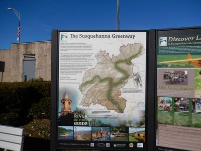
The Susquehanna Greenway is a corridor of farms, forests, parks, trails and river towns that connects people to the natural and cultural treasures of the Susquehanna River. Nearly 500 miles in length, it is Pennsylvania’s largest greenway, and it is waiting for you to explore.
Why is the Susquehanna Watershed Important?
The Susquehanna’s water, timber, coal, and minerals built and powered a growing nation in the 1800s and 1900s. However, clear-cutting timber and coal mining without proper environmental protections in place led to the legacy of contaminated soils and streams for subsequent generations to clean up.
Thanks to the work of early Pennsylvania conservationists like Gifford Pinchot, Joseph Rothrock and Rachel Carson, our forests and streams have been largely restored and we now understand the link between land used, clean water and healthy communities. The Susquehanna Greenway continues this conservation movement and provides opportunities for exploration of its river towns, land and water trails. To learn more, explore or get involved.
(Inscription under the image in the center)
The Susquehanna River watershed provides drinking water to over six million people and nearly half of the fresh water entering the Chesapeake Bay, our nation’s largest estuary.
(Inscription beside the image in the center)
Named for its earliest inhabitants, the Susquehannock Indians, the scenic beauty and rich natural resources of the Susquehanna River have continued to draw people to its shores.
Erected by Pennsylvania Department of Conservation and Natural Resources.
Topics. This historical marker is listed in these topic lists: Environment • Waterways & Vessels.
Location. 41° 8.281′ N, 77° 26.508′ W. Marker is in Lock Haven, Pennsylvania, in Clinton County. Marker is on East Water Street (PA120). The marker is near the Veterans Bridge. Touch for map. Marker is in this post office area: Lock Haven PA 17745, United States of America. Touch for directions.
Other nearby markers. At least 8 other markers are within walking distance of this marker. Fort Reed Stockade (a few steps from this marker); Lock Haven Flood Protection Project (a few steps from this marker); Clinton County (within shouting distance of this marker); American Hero (within shouting distance of this marker); Lock Haven (within shouting distance of this marker); Clinton County Veterans Memorial (within shouting distance of this marker); Pennsylvania Canal (about 400 feet away, measured in a direct line); Harmon Field (approx. 0.6 miles away). Touch for a list and map of all markers in Lock Haven.
Credits. This page was last revised on June 16, 2016. It was originally submitted on November 28, 2015, by Don Morfe of Baltimore, Maryland. This page has been viewed 262 times since then and 10 times this year. Photos: 1, 2. submitted on November 28, 2015, by Don Morfe of Baltimore, Maryland. • Bill Pfingsten was the editor who published this page.

