
El Asintal, Retalhuleu, Guatemala — Central America
Piecitos Station
Photographed by J. Makali Bruton, December 29, 2015
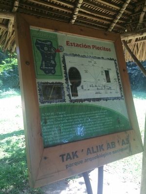
1. Piecitos Station Marker

Altar 46 - "Piecitos"
Roca colocada en la fila este de monumentos sobre la superficie de la gran Estructura 7. Tiene un par de huellas de pies genialmente esculpidos en su superficie. Estas huellas estan orientadas 115°NE, exactamente donde aparece el sol en el solsticio de invierno el 21 de diciembre. Esto nos indica que los antiguos mayas estaban observando el trayecto del sol para poder contar los dias del año y con lo cual de desarolla el sistema de cuenta larga. Las masivas ofrendas depositadas en el lugar testigua la importancia de este evento que se esta conmemorando desde alrededor de 100 d.C. a inicios de b'aqtun 8, finales del Preclasico Tardío.
Mapa de los monumentos encima de la estructura 7 y indicaciones sobre dónde pasan los solticios del año
Alta 46 - "Piecitos" ("Little Feet")
This rock in this line of monuments here on top of Structure 7 has a pair of footprints deftly carved into its surface. These prints are oriented to 115° NE, exactly in the direction where the sun appears on the winter solstice of December 21. This indicates to us that the ancient Maya were observing the sun's
this page online
Map of the monuments on top of Structure 7 and indications of where the solstice occurs during the year.
Topics. This historical marker is listed in these topic lists: Anthropology & Archaeology • Indigenous Peoples and Communities. A significant day of the year for for this entry is December 21.
Location. 14° 38.275′ N, 91° 43.9′ W. Marker is in El Asintal, Retalhuleu. It can be reached from RD-REU-13. Km. 199, Tak'alik Ab'aj Archaeological Park, Reserva Natural Privada Santa Margarita, Municipio El Asintal. Touch for map. Marker is in this post office area: El Asintal, Retalhuleu 11009, Guatemala. Touch for directions.

Regionally, it is in North America, specifically in Central America, in Mesoamerica, on the Ring of Fire, on the Pacific Rim, and in the Western Hemisphere. Historically, it finds itself in
Photographed by J. Makali Bruton, December 29, 2015
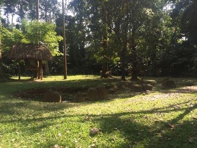
2. Piecitos Station Marker
The line of monuments on top of Structure 7 can be seen in the foreground. The "Piecitos" Altar (Altar 46) is to the left of this view.
Other nearby markers. At least 8 other markers are within walking distance of this marker: Estación Entierro No. 2 (within shouting distance of this marker); Estación Guacalitos (about 90 meters away); Tanmi Tnam Plaza (about 120 meters away); Estación Recorrido (about 150 meters away); Estación Mapa del Sitio (about 150 meters away); Stela 18 Station (about 150 meters away); Sweat Lodge (approx. 0.3 kilometers away); Plaza Tukur Balam (approx. 0.3 kilometers away). Touch for a list and map of all markers in El Asintal.
Another marker is no longer nearby. Guacalitos Station (was about 90 meters away, measured in a direct line but has been permanently removed).
Regarding Piecitos Station. Tak'alik Ab'aj is the oldest known Mayan site, dating from 900 BCE, and was continuously inhabited until ca. 1000. The site is unique in that it has many examples of Olmec influence on early Mayan culture.
A b'aqtun is a period of time equal to about 394 years. The period of the 8th and 9th b'aqtuns correspond to the period of the highest development in ancient Mayan society.
The Long
Photographed by J. Makali Bruton, December 29, 2015
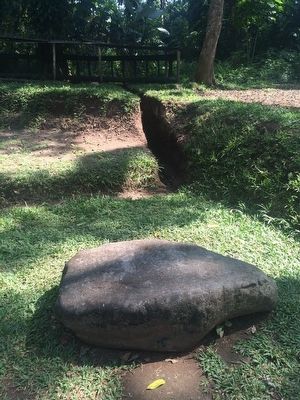
3. Altar 46 - "Piecitos"
Facing northeast towards the direction of the rising sun on the winter solstice. The engraving of the feet is very faded and unfortunately the stone is not currently protected from further erosion or damage.
Photographed by J. Makali Bruton, December 29, 2015
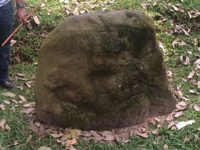
4. A monument on top of Structure 7 of a ruler holding a jaguar and a deer.
Credits. This page was last revised on October 4, 2026. It was originally submitted on January 11, 2016, by J. Makali Bruton of Washington, District of Columbia. This page has been viewed 352 times since then and 11 times this year. Photos: 1, 2, 3, 4. submitted on January 11, 2016, by J. Makali Bruton of Washington, District of Columbia.
