Piney River in Nelson County, Virginia — The American South (Mid-Atlantic)
American Cyanamid
The Virginia Blue Ridge Railway Trail
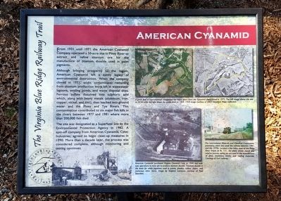
Although bringing prosperity to the region, American Cyanamid left a costly legacy of environmental destruction. When the company closed in 1971, the acidic contaminates remaining from titanium production were left in wastewater lagoons, settling ponds, and waste disposal sites. Ferrous sulfate dissolved into sulphuric acid which, along with heavy metals (aluminum, iron, copper, nickel, and zinc), then leached into ground water and the Piney and Tye Rivers. This contamination contributed to six major fish kills in the rivers between 1977 and 1981 where more than 200,000 fish died.
The site was designated as a Superfund Site by the Environmental Protection Agency in 1982. A spin-off company from American Cyanamid, Cytec Industries, agreed to begin clean-up measures in 1990. More than a decade later, the process was considered complete, although monitoring and testing continues.
(captions)
(top right) A great deal of environmental remediation has taken place since the Cyanamid plant closed in 1971. The left image shows the site in 2010, while the right shows the active plant in 1959. 1959 image courtesy of USGS Historical Maps Collection.
(bottom center) American Cyanamid purchased Virginia Chemical Corp. in 1944 and took over operations to mine ore to produce titanium dioxide. Titanium dioxide is the basis for white pigments used in paints, plastics, rubber, paper, and numerous other items. Image by Stephen Lamanna courtesy of Paul Saunders.
(bottom right) The International Minerals and Chemical Corporation processing plant also used the railway between 1941 and the 1970s. Located a few miles west of the Piney River Depot at Rt. 151, the plant shown above was used to process aplite, on ore used in the manufacture of glass, insulation, bricks, and roofing materials. Courtesy of Carl Lathrop.
Erected by Virginia Blue Ridge Railway Trail.
Topics. This historical marker is listed in these topic lists: Environment • Industry & Commerce • Railroads & Streetcars • Waterways & Vessels.
Location. 37° 42.441′ N, 79° 1.195′ W. Marker is in Piney River, Virginia, in Nelson County. Marker can be reached from Patrick Henry Highway (Virginia Route 151) 0.4 miles Firehouse Road (Virginia Route 675), on the left when traveling south. Located along the Virginia Blue Ridge Railway Trail. Touch for map. Marker is at or near this postal address: 3124 Patrick Henry Hwy, Piney River VA 22964, United States of America. Touch for directions.
Other nearby markers. At least 8 other markers are within 5 miles of this marker, measured as the crow flies. The Virginia Blue Ridge Railway (about 700 feet away, measured in a direct line); Hurricane Camille (approx. 0.3 miles away); The Rivers (approx. 2.6 miles away); Cabellsville (approx. 4.4 miles away); The Reverend Robert Rose (approx. 4.6 miles away); a different marker also named Hurricane Camille (approx. 4.7 miles away); Thomas Massie (approx. 4.8 miles away); Action at Tye River (approx. 4.9 miles away). Touch for a list and map of all markers in Piney River.
Also see . . . Virginia Blue Ridge Railway Trail. (Submitted on March 9, 2016.)
Credits. This page was last revised on June 16, 2016. It was originally submitted on March 9, 2016, by Bernard Fisher of Richmond, Virginia. This page has been viewed 786 times since then and 44 times this year. Photos: 1, 2. submitted on March 9, 2016, by Bernard Fisher of Richmond, Virginia.

