Mission Bay in San Francisco City and County, California — The American West (Pacific Coastal)
Chutchui and Sitlintac
Inscription.
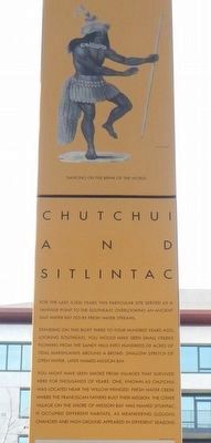
For the last 5,000 years this particular site served as a vantage point to the southeast, overlooking an ancient salt water bay fed by fresh water streams.
Standing on this bluff three to four hundred years ago, looking southeast, you would have seen small creeks flowing from the sandy hills into hundreds of acres of tidal marshlands around a broad, shallow stretch of open water, later named Mission Bay.
You might have seen smoke from villages that survived here for thousands of years. One, known as Chutchui, was located near the willow-fringed, fresh-water creek where the Franciscan fathers built their mission. The other village on the shore of Mission Bay was named Sitlintac; it occupied different habitats, as meandering sloughs changed and high ground appeared in different seasons.
(illustration 2)
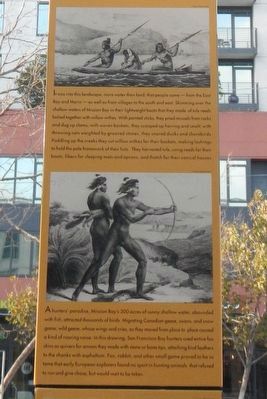
It was into this landscape, more water than land, that people came - from the East Bay and Marin - as well as from villages to the south and east. Skimming over the shallow waters of Mission Bay in their lightweight boats that they made of tule reeds lashed together with willow withes. With pointed sticks, they pried mussels from rocks and dug up clams; with woven basket, they scooped up herring and smelt, with throwing nets weighted by grooved stones, they snared ducks and shorebirds. Paddling up the creek they cut willow withes for their baskets, making lashings to hold the pole framework of their huts. They harvested tule, using reeds for their boats, fibers for sleeping mats and aprons, and thatch for their conical houses.
(illustration 3)
A hunter's paradise, Mission Bay's 300 acres of sunny shallow water, abounded with fish, attracted thousands of birds. Migrating Canadian geese, swans, and snow geese; wild geese, whose wings and cries, as they moved from place to place caused a kind of roaring noise. In this drawing, San Francisco Bay hunters used entire fox skins as quivers for arrows they made with stone or bone tips, attaching bird feathers to the shanks with asphaltum. Fox, rabbit, and other small game animals proved to be so tame that early European explorers found no sport in hunting animals that refused to run and give chase but would wait to be taken.
(illustration 4)
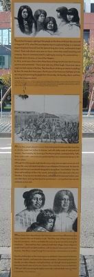
The earliest European sighting of the people on the shore of Mission Bay occurred in August of 1775, when Pilot Juan Baptisto Aquirre explored the bay in a redwood dugout long boat lowered from the Spanish brig San Carlos, anchored at Angel Island, Three individuals were seen on shore, where they stood lamenting and weeping. Aguirre commemorated his sighting by naming this protected bay - Ensenada de los Llorenes, or Cove of
the Weepers.
In 1816, artist Louis Choris drew these faces of long time Mission San Francisco converts and commented: "I have never seen any of them laugh, I have never seen a single one look anyone in the face. They have the air of taking no interest in anything." By then, for more than forty years, the Mission at San Francisco has been actively recruiting and converting the people of Mission Bay, the East Bay, Marin, and from across the Carquinez Straits.
In September of 1816, arriving on the Rurik under the command of Captain Otto von Katzebue, artist Louis Choris drew these faces of long time Mission San Francisco converts. Choris identified each portrait with a particular tribal group given by the individual as a place of origin. We can be confident that these are authentic representations, because on the same voyage Choris made other drawings of the Inuit people and Polynesians, whose portraits could be interchanged with their descendants today.
(illustration 5)
Mission Bay people played music on flutes fashioned of hollow alder branches, on whistles made of hollow bird bone, and with rattles made of seed pods and cocoons. Fascinated by the chanting of the Mission priests, accompanied by bells, flutes, and a violin, native converts performed their own ceremonial dances in the Mission plaza.
Although the
tribal people might decide many many times to reject conversion and Mission life, once individuals had taken a vow to become Christianized, the Spanish fathers took this as a sacred oath designed to rescue these "Lost Children" from the observed hardships of life in this world, and tortures of the damned in the next. Therefore, it any converts decided to leave, soldiers and Christianized Indians were sent after them, to bring them back for punishment - saving them from eternal retribution as lost souls.
(illustration 6)
When Choris drew these Mission San Francisco converts from different bay area tribes, Captain Otto von Kotzebue wrote: "The filthy state of these barracks was beyond conception, which is probably the cause of great mortality among the inhabitants..." Removed from their scattered small tribal villages, these indigenous people lived in such crowded conditions, with no natural immunization to foreign diseases, that illness swept through first one mission and moved on to another.
"Very few children born at the missions grew to adulthood. Gastrointestinal diseases flourished. Syphilis, and tuberculosis became endemic. Occasional epidemics of measles, possibly influenza and typhoid fever, ran through mission populations. Recorded death rates at missions Santa Clara and San Francisco between 1780 and 1830 were among the highest continually
sustained death rates anywhere." -- Dr. Randall Milliken, A Time of Little Choice
(black and white tiles on the left side of the pylon)
Narrative of a Voyage to the Pacific, 1826, Captain Frederic W. Beechey, on H.M.S. Blossom, concerning life at San Francisco's Mission:
... If any captured Indians show a repugnance to conversion it is the practice to imprison them for a few days, and then allow them to breath a little fresh air in a walk around the mission to observe the happy life of their converted countrymen after which they are shut up, and continue to be incarcerated until their readiness to renounce the religion of their forefathers... Having become Christians they are put to learning trades, if they have good voices, (they) are taught music... there are weavers, tanners, shoemakers, brick layers, carpenters, blacksmiths. Others are taught to rear cattle and horses, while the females card, clean and spin wool...
The Testimony of Captured Run-away Converts from the Mission San Francisco
Lt. Jose Arguello, along with other Presidio soldiers, captured these run-aways, and on August 12, 1797 took down their personal reasons for escaping from the Mission. He filed his military report with Spanish authorities.
Tiburcio -- He testified that after his wife and daughter died, on five separate occasions father Danti ordered him whipped because he was crying, for theses reasons he fled.
Marciano -- He offered no reason for fleeing other than he had become sick both his wife and two children lived through the epidemic of 1795.
Marin -- He testified that he left due to his hunger and because they had put him in stocks when he was sick, on orders from the Alcalde.
Ostano -- He testified that his motive for having fled was that his wife, one child, and two brothers had died, and because he fought with another Indian who had been directing his work group.
Liberato -- He testifies that he left because his mother, two brothers and three nephews died, all of hunger. So that he would not also die of hunger, he fled.
Jose Manuel -- He testifies that when they went to bring wood from the mountains, Raymond ordered them to bring him water, When he wouldn't do it, Raymundo hit him with a heavy cane, rendering his hand useless.
Magno -- He declared that he ran away because his son having been sick, he took care of him and therefore could not go to work. As a result he was given no ration, and is son died of hunger.
Homobono -- He testifies that his motive for fleeing was that his brother had died on the other shore and when he cried for him at the Mission, they whipped him. Also, the Alcalde had hit him with a heavy club when he went to look for mussels on the beach.
Otolon -- He reports that he fled because his wife did not care for him or bring him food. The vaquero, Salvador had sinned with her. Then Father Antonio ordered him whipped because he was not looking out for said woman, his wife.
Milan -- He declared that he was working all day in the tannery without any food for either himself, his wife or his child. One afternoon after he left he went to look for clams to feed his family. Father Danti whipped him. The next day he fled to the other shore, where his wife and child died.
Prospero -- He declared that he had gone out one night to the lagoon to hunt for ducks for food. For this Father Antonio Danti ordered him stretched out and beaten. That following week he was whipped again for going out into the paseo.
Archiva General de la Nation, Mexico City, Rama Californias Toma 65, Doc. 106. Transcribed from the Spanish in "Manuscripts in Translation" from A Time of Little Choice by Randal Milliken, Ballena Press, Menlo Park, 1995
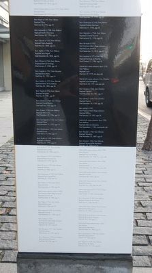
(black and white tiles on the back and right side of the pylon)
1777 -- 1787
All of the individuals listed here were baptized at the Mission San Francisco de Asis, founded in 1776, and later known as the Mission Dolores.
When baptized, Native Americans gave their own name, as well as their tribal village of origin. Franciscan priests gave them a new Spanish name. Both names are shown here, as they appear on Mission baptismal records from June of 1777 through January of 1787.
Six thousand, three hundred and sixteen individuals were baptized at San Francisco's Mission during this first decade. They hailed from many far flung regional tribal villages.
The one-hundred and six individuals listed here came from the six tribal villages in the territory that would become San Francisco.
Mission Bay's vanished people came from two nearby villages. Sitlintac, on the shore of the once great bay; and from Chutchui, close by the site chosen for San Francisco's Mission.
Shown here with his help and kind permission and published as
A Time of Little Choice:
The Disintegration of Tribal Culture in the San Francisco Bay Area 1769-1810
Ballena Press, Melo Park, 1995
Erected by San Francisco Art Commission for the Waterfront Transportation Projects.
Topics. This historical marker is listed in these topic lists: Colonial Era • Native Americans.
Location. 37° 46.625′ N, 122° 23.594′ W. Marker is in San Francisco, California, in San Francisco City and County. It is in Mission Bay. Marker is on King Street / The Embarcadero near 4th Street, on the right when traveling north. Touch for map. Marker is at or near this postal address: 270 King Street, Sacramento CA 94207, United States of America. Touch for directions.
Other nearby markers. At least 8 other markers are within walking distance of this marker. Rammaytush (within shouting distance of this marker); 150 Years of Service on the Oldest Railroad in the West With Continuous Passenger Service (about 500 feet away, measured in a direct line); Willie Howard Mays, Jr. (about 600 feet away); Steamboat Point (about 600 feet away); Peter R. Maloney (4th Street) Bridge (about 700 feet away); The Francis "Lefty" O'Doul Third Street Bridge (about 800 feet away); a different marker also named Willie Howard Mays, Jr. (approx. 0.2 miles away); Juan Antonio Marichal Sanchez (approx. 0.2 miles away). Touch for a list and map of all markers in San Francisco.
Credits. This page was last revised on January 28, 2024. It was originally submitted on March 13, 2016, by Barry Swackhamer of Brentwood, California. This page has been viewed 1,145 times since then and 124 times this year. Photos: 1, 2, 3, 4, 5. submitted on March 13, 2016, by Barry Swackhamer of Brentwood, California.
