Near Perrysburg in Wood County, Ohio — The American Midwest (Great Lakes)
to Brady's Island / to Fort Miami
Ohio Revolutionary Memorial Trail
— Harrison's March —
Revolutionary
Memorial
Trail
Text on West Side :
March • 1813
- - - - -
28
Miles to
Brady's
Island
Text on East Side :
March • 1813
- - - - -
6
Miles to
Fort
Miami
Erected 1930 by Ohio Revolutionary Memorial Commission. (Marker Number A125.)
Topics and series. This historical marker is listed in these topic lists: Forts and Castles • Native Americans • War of 1812 • Wars, US Indian. In addition, it is included in the Ohio Revolutionary Memorial Commission series list. A significant historical year for this entry is 1813.
Location. Marker is missing. It was located near 41° 32.444′ N, 83° 34.839′ W. Marker was near Perrysburg, Ohio, in Wood County. Marker was on Fremont Pike (U.S. 20) east of Thompson Road, on the right when traveling east. Nothing remains of this marker, but according to my vehicle's odometer this marker's probable site is exactly 5.9 miles east of the site of the Ohio Revolutionary Memorial Commission marker for Fort Miami. Touch for map. Marker was at or near this postal address: 9633 Fremont Pike, Perrysburg OH 43551, United States of America. Touch for directions.
Other nearby markers. At least 8 other markers are within 3 miles of this location, measured as the crow flies. The Simmons House (approx. 0.7 miles away); Perrysburg (approx. 1.2 miles away); First Union School House (approx. 1˝ miles away); Girls Soccer 2012 / Girls Cross Country 2021 (approx. 1˝ miles away); a different marker also named Perrysburg (approx. 1.8 miles away); Al Rava (approx. 2.1 miles away); The Maumee and Western Reserve Road / Turnpike Milestones (approx. 2.1 miles away); Islamic Center of Greater Toledo (approx. 2.1 miles away). Touch for a list and map of all markers in Perrysburg.
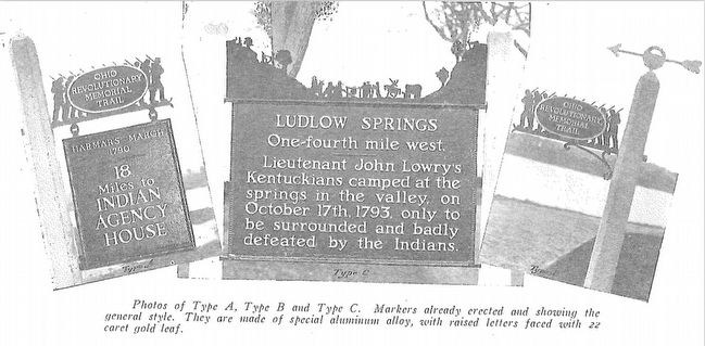
More about this marker. This historical marker is part of the Ohio Revolutionary Memorial Trail series (type A) which was put in place in 1930 to celebrate the 150th anniversary of the Ohio's Revolutionary War era Battle of Piqua, by the Ohio Revolutionary Memorial Commission.
In order to accomplish this, in 1929 the state of Ohio created the Ohio Revolutionary Memorial Commission, and then in 1930 this commission created 22 military trails, throughout western Ohio, between Cincinnati, Ohio on the state's southern border and Toledo, Ohio on the state's northern border. Each of these military
trails represented the routes, or trails, used by military leaders during either the Revolutionary War, the Indian Wars, or the War of 1812. Each of these military routes connected various related historical sites, that were marked with Ohio Revolutionary Memorial Commission (type C) markers, along each of military trails.
The routes of these military trails were in turn marked by type A and type B Ohio Revolutionary Memorial Commission markers that served as directional (type B) and distance (type A) markers. This particular marker is one of the type A markers of the Ohio Revolutionary Memorial Trail series.
Originally, back in 1930, according to the ORMC 1931 Planning Report, there were erected 168 some of these Ohio Revolutionary Memorial Commission, type A, markers (see page 54). To date, I know of only 3 of these type A markers that have been located and posted on the Historical Marker database (markers A95, A96, and A1340). A large number of them are presently missing, including this particular marker, A125, which is listed on page 66 of the 1931, Ohio Revolutionary Memorial Commission's Planning Report.
Also see . . . Ohio Revolutionary Memorial Trail System. A description of the Revolutionary Memorial Trail System developed by the state of Ohio in 1929 - 1930. (Submitted on March 31, 2016, by Dale K. Benington of Toledo, Ohio.)
Additional commentary.
1. Ohio Revolutionary Memorial Trail System Markers
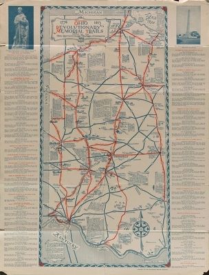
This particular Ohio Revolutionary Memorial Commission (ORMC), Type A marker, once helped to mark the military marches of General Harrison during the War of 1812. According to the ORMC 1931 Planning Report (see page 57), it was used on the portion of the Ohio Revolutionary Memorial Trail System that connected Fort Meigs to Fremont. According to the Ohio Revolutionary Memorial Trails cartographic map, that was issued by the ORMC in 1930, this marker was situated along the roadway that in 1930 was US 20, and today, this roadway remains as US 20, but it is a much improved US 20.
Back in 1930, when this marker was originally erected, US 20 was most likely a two lane roadway, whereas today, it is a four lane highway.
Along some portions of the Ohio Revolutionary Memorial Trail System, it is difficult to identify the probable location of these markers because the roadways of 1930 are so much different from the present day roadways. Many of the original roadways have been re-routed or by-passed, or in some cases given new route number designations. However, for this particular marker, the Ohio Revolutionary Memorial Trail System follows the same path of the original (but widened by 2 additional lanes) roadway.

Photographed By Ohio Revolutionary Memorial Commission
4. Ohio Revolutionary Memorial Commission Marker Types
View of the three types of markers used by the Ohio Revolutionary Memorial Commission. The marker on the left is a type A marker (just like our missing marker), the marker in the middle is a type C, and the marker on the right is a type B.
— Submitted March 31, 2016, by Dale K. Benington of Toledo, Ohio.
Credits. This page was last revised on July 26, 2022. It was originally submitted on March 31, 2016, by Dale K. Benington of Toledo, Ohio. This page has been viewed 422 times since then and 33 times this year. Photos: 1, 2, 3, 4, 5. submitted on April 23, 2016, by Dale K. Benington of Toledo, Ohio.


