Cranbury in Middlesex County, New Jersey — The American Northeast (Mid-Atlantic)
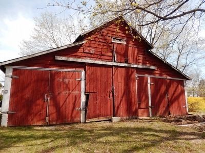
Parsonage Barn
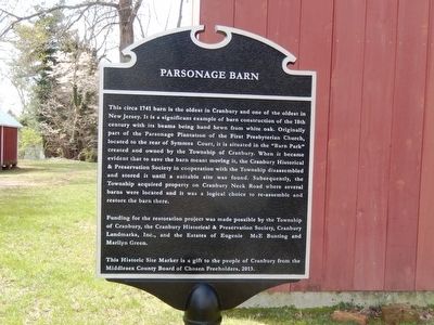
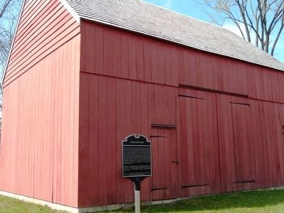
This circa 1741 barn is the oldest in Cranbury and one of the oldest in New Jersey. It is a significant example of barn construction of the 18th century with its beams being hand hewn from white oak. Originally part of the Parsonage Plantation of the First Presbyterian Church, located to the rear of Symmes Court it is situated in the “Barn Park” created and owned by the Township of Cranbury. When it became evident that to save the barn meant moving it, the Cranbury Historical & Preservation Society in cooperation with the Township disassembled and stored it until a suitable site was found. Subsequently, the Township acquired property on Cranbury Neck Road where several barns were located and it was a logical choice to re-assembled and restore the barn there.
Funding for the restoration project was made possible by the Township of Cranbury, the Cranbury Historical & Preservation Society, Cranbury Landmarks, Inc., and the Estates of Eugenie McE Bunting and Marilyn Green.
The Historic Site Marker is a gift to the people of Cranbury from the Middlesex County Board of Chosen Freeholders, 2013
Topics. This historical marker is listed in these topic lists: Agriculture • Colonial Era • Parks & Recreational Areas. A significant historical year for this entry is 1741.
Location. 40° 18.294′
Other nearby markers. At least 8 other markers are within 3 miles of this marker, measured as the crow flies. Site of House of Dr. Hezekiah Stites (about 400 feet away, measured in a direct line); The First Presbyterian Church and Cemetery (approx. ¼ mile away); Cranberry Mills (approx. 0.3 miles away); Site of Encampment (approx. 0.4 miles away); The Cranbury Dam (approx. 0.4 miles away); Todd Beamer (approx. 0.7 miles away); The Second Presbyterian Church of Cranbury (approx. 0.7 miles away); East Windsor Township Civil War Monument (approx. 2.4 miles away). Touch for a list and map of all markers in Cranbury.
Credits. This page was last revised on January 4, 2021. It was originally submitted on April 12, 2016, by Don Morfe of Baltimore, Maryland. This page has been viewed 404 times since then and 18 times this year. Photos: 1, 2, 3, 4, 5. submitted on April 12, 2016, by Don Morfe of Baltimore, Maryland. • Bill Pfingsten was the editor who published this page.
