Near Williamsburg in York County, Virginia — The American South (Mid-Atlantic)
Whitaker's House
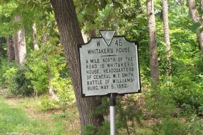
Photographed by Kathy Walker, August 11, 2007
1. Whitaker's House Marker
Erected 1974 by Virginia Historic Landmarks Commission. (Marker Number W-45.)
Topics and series. This historical marker is listed in this topic list: War, US Civil. In addition, it is included in the Virginia Department of Historic Resources (DHR) series list. A significant historical date for this entry is May 5, 1730.
Location. 37° 14.955′ N, 76° 39.616′ W. Marker is near Williamsburg, Virginia, in York County. It is on Pocahontas Trail (Virginia Route 60) 0.1 miles east of Route 199, on the right when traveling west. Touch for map. Marker is in this post office area: Williamsburg VA 23185, United States of America. Touch for directions.

Regionally, this marker is on Virginia’s Peninsula, in Coastal Virginia, and in the Hampton Roads Metropolitan Area. It is also in the American South, specifically in the Upper South, in the Tidewater, and on the Eastern Seaboard. Globally, it is in the North Atlantic Region, North America, the Western Hemisphere, the Western World, and the Anglosphere. Historically,
this page online
Other nearby markers. At least 8 other markers are within 2 miles of this marker, measured as the crow flies: The Jersey Boys (approx. 0.6 miles away); Battle of Williamsburg (approx. one mile away); Confederate Soldiers and Sailors Monument (approx. 1.1 miles away); Fort Magruder (approx. 1.1 miles away); a different marker also named Fort Magruder (approx. 1.1 miles away); a different marker also named Vineyard Tract (approx. 1.2 miles away); Loch Ness Monster (approx. 1.3 miles away); Loch Ness Coaster (approx. 1.3 miles away). Touch for a list and map of all markers in Williamsburg.
Other markers no longer nearby. Kingsmill (was approx. 0.4 miles away but has been permanently removed); Magruder’s Defenses (was approx. 1.1 miles away but has been confirmed missing); Vineyard Tract (was approx. 1.2 miles away but has been replaced with another marker now near it).
Credits. This page was last revised on October 9, 2022. It was originally submitted on July 24, 2008, by Kathy Walker of Stafford, Virginia. This page has been viewed 2,202 times since then and 124 times this year. Photo 1. submitted on July 24, 2008, by Kathy Walker of Stafford, Virginia. • Craig Swain was the editor who published this page.
