Deltaville in Middlesex County, Virginia — The American South (Mid-Atlantic)
Captain John Smith’s Shallop
Explorer
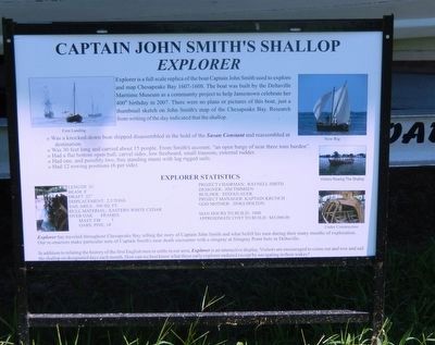
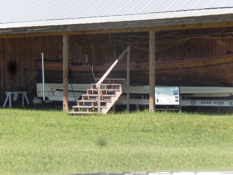
Explorer is a full scale replica of the boat Captain John Smith used to explore and map Chesapeake Bay 1607-1608. The boat was built by the Deltaville Maritime Museum as a community project to help Jamestown celebrate her 400th birthday in 2007. There were no plans or pictures of this boat, just a thumbnail sketch on John Smith’s map of the Chesapeake Bay. Research from writing of the day indicated that the shallop.
• Was a knocked-down boat shipped disassembled in the hold of the Susan Constant and reassembled at destination.
• Was 30 feet long and carried about 15 people. From Smith’s account, “an open barge of near three tons burden”.
• Had a flat bottom open hull, carvel sides, low freeboard, small transom, external rudder.
• Had one, and possibly two, free standing masts with lug rigged sails.
• Had 12 rowing positions (6 per side).
Explorer Statistics
Length 31’ Beam 8’ Draft 22” Displacement: 2.5 tons Sail Area: 300 sq. ft. Hull Material: Eastern white cedar over oak frames. Mast: Fir Oars: Pine, 14” Man hours to build: 1000 Approximate cost to build: $65,000.00.
Project Chairman: Raynell Smith Designer: Jim Thimsen Builder: Stefan Auer Project Manager: Kaptain Krunch God Mother: Jinks Holton
Explorer has traveled throughout Chesapeake Bay telling the story of Captain John Smith and what befell his men during their many months of exploration. Our re-enactors make particular note of Captain Smith’s near death encounter with a stingray at Stingray Point here in Deltaville.
In addition to relating the history of the first English men to settle in our area, Explorer is an interactive display. Visitors are encouraged to come out and row and sail the Shallop on designated days each month. How can we best know that these early explorer endured except by navigating in their wakes?
Erected by Deltaville Maritime Museum.
Topics. This historical marker is listed in these topic lists: Exploration • Man-Made Features • Waterways & Vessels.
Location. 37° 33.175′ N, 76° 19.518′ W. Marker is in Deltaville, Virginia, in Middlesex County. Marker can be reached from Jackson Creek Road (Route 660) 0.1 miles south of Bucks View Lane (Route 683), on the left when traveling south. The Explorer is located on the grounds of the Deltaville Maritime Museum. Touch for map. Marker is at or near this postal address: 287 Jackson Creek Road, Deltaville VA 23043, United States of America. Touch for directions.
Other nearby markers. At least 8 other markers are within walking distance of this marker. Oyster Tongs (about 400 feet away, measured in a direct line); Boarding Cutter (about 400 feet away); F.D. Crockett (about 400 feet away); Marine Railway (about 400 feet away); Deltaville Dollies (about 400 feet away); Confederate Boarding Cutter (about 400 feet away); Explorer (about 500 feet away); Ruark Sculpture Garden (about 500 feet away). Touch for a list and map of all markers in Deltaville.
Credits. This page was last revised on August 29, 2016. It was originally submitted on August 26, 2016, by Don Morfe of Baltimore, Maryland. This page has been viewed 636 times since then and 32 times this year. Photos: 1, 2, 3. submitted on August 26, 2016, by Don Morfe of Baltimore, Maryland. • Bernard Fisher was the editor who published this page.


