Melchor de Mencos, Petén, Guatemala — Central America
East Causeway Residential Zone
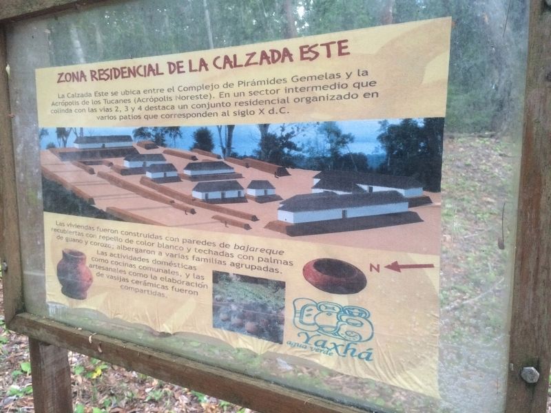
Zona Residencial de la Calzada Este
La Calzada Este se ubica entre el Complejo de Pirámides Gemelas y la Acrópolis de los Tucanes (Acrópolis Noreste). En un sector intermedio que colinda con las vías 2, 3 y 4 destaca un conjunto residencial organizado en varios patios que corresponden al siglo X d.C.
Las viviendas fueron construidas con paredes de bajareque recubiertas con repello de color blanco y techadas con palmas de guano y corozo; albergaron a varias familias agrupadas. Las actividades domésticas como cocinas comunales, y las artesanales como la elaboración de vasijas cerámicas fueron compartidas.
East Causeway Residential Zone
The East Causeway is located between the Twin Pyramid Complex and the Acropolis of the Toucans (Northeast Acropolis). It was an intermediate area which adjoins the paths numbered 2, 3 and 4. A highlight of the area is the organized residential complex made of several patios corresponding to the 10th century AD.
The houses were built with walls of bajareque (wattle and daub) coated with white plaster and roofed with guano and corozo palm leaf thatch. The residences were organized into several familial units. Domestic activities such as communal cooking and artisan work like making ceramic vessels were shared.
Topics. This historical marker is listed in these topic lists: Anthropology & Archaeology • Man-Made Features • Native Americans.
Location. 17° 4.404′ N, 89° 24.002′ W. Marker is in Melchor de Mencos, Petén. The marker is along the East Causeway in Yaxhá Archaeological Park. The park is some 5 kilometers north of the village of El Zapote, turning from the CA13 road. Touch for map. Marker is in this post office area: Melchor de Mencos, Petén 17011, Guatemala. Touch for directions.
Other nearby markers. At least 8 other markers are within walking distance of this marker. Intersection of the Eastern and Quarry Causeways (about 150 meters away, measured in a direct line); The Quarry Causeway (about 180 meters away); Plaza of the Columns (about 210 meters away); The Eastern Acropolis of Yaxhá (about 240 meters away); Sacrificial Pyramid (approx. 0.2 kilometers away); The Palace's Ballgame (approx. 0.3 kilometers away); The Plaza of the Birds (approx. 0.3 kilometers away); Minor Astronomical Complex at Yaxhá (approx. 0.3 kilometers away). Touch for a list and map of all markers in Melchor de Mencos.
Credits. This page was last revised on March 2, 2018. It was originally submitted on October 31, 2016, by J. Makali Bruton of Accra, Ghana. This page has been viewed 283 times since then and 3 times this year. Photos: 1, 2. submitted on October 31, 2016, by J. Makali Bruton of Accra, Ghana.

