Harpers Ferry in Jefferson County, West Virginia — The American South (Appalachia)
Harper Cemetery
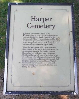
Passing through this region in 1747, Robert Harper — a Pennsylvania architect contracted to build a Quaker church in the Shenandoah Valley — was so impressed by the beauty of this place and the water-power potential of the Potomac and Shenandoah Rivers that he settled here and founded Harpers Ferry.
When Harper died in 1782, there were only three houses in the town. Optimistic about the community's potential for growth, however, Harper had set aside this 4-acre cemetery. Childless, Harper left most of his estate to his niece, Sarah, who subsequently married a Wager. As you wander around the cemetery, you'll find the grave markers of some of Sarah Wager's descendants as well as stones of Irish and German immigrants who settled in this area during the 1830's.
Topics. This historical marker is listed in these topic lists: Cemeteries & Burial Sites • Colonial Era. A significant historical year for this entry is 1747.
Location. 39° 19.427′ N, 77° 44.074′ W. Marker is in Harpers Ferry, West Virginia, in Jefferson County. Marker is on Fillmore Street, 0.2 miles east of Columbia Street, on the right when traveling east. Marker can be reached by walking through the cemetery downhill from Lockwood House and bearing right toward the woods. Alternately, it can be reached from a side trail off the Appalachian Trail just above Jefferson Rock. Touch for map. Marker is in this post office area: Harpers Ferry WV 25425, United States of America. Touch for directions.
Other nearby markers. At least 8 other markers are within walking distance of this marker. Nathan Cook Brackett (within shouting distance of this marker); Lockwood House (about 300 feet away, measured in a direct line); Revolutionary War Soldier (about 300 feet away); Brackett House (about 500 feet away); Jefferson Rock (about 500 feet away); a different marker also named Jefferson Rock (about 500 feet away); Shenandoah Canal (about 600 feet away); Riley House (about 700 feet away). Touch for a list and map of all markers in Harpers Ferry.
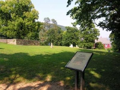
More about this marker. The cemetery is on a hill with a lovely view.
Credits. This page was last revised on April 26, 2020. It was originally submitted on August 13, 2008, by Linda Walcroft of Woodstock, Virginia. This page has been viewed 2,701 times since then and 25 times this year. Photos: 1, 2. submitted on August 13, 2008, by Linda Walcroft of Woodstock, Virginia. 3. submitted on April 25, 2020, by Larry Gertner of New York, New York. 4. submitted on August 13, 2008, by Linda Walcroft of Woodstock, Virginia. • Craig Swain was the editor who published this page.


