Lamar in Prowers County, Colorado — The American Mountains (Southwest)
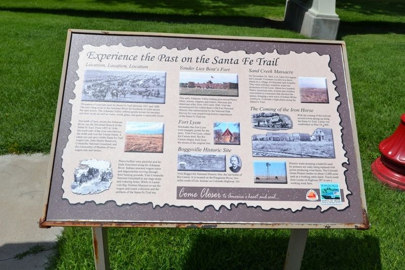
Experience the Past on the Santa Fe Trail
Location, Location, Location
Thousands of caravans used the Santa Fe Trail between 1821 and 1880. The trail clung close to the Arkansas River for hundreds of miles across the open plains. The Arkansas Valley offered gentle terrain for travelers and their stock, as well as water, wood, grass, and game – especially bison.
Just north of here, across the Arkansas River, ran the Mountain Branch of the Santa Fe Trail. From 1821 to 1846, the south side of the river was Mexico, the north side was the United States. A sharp eye can spot visible Santa Fe Trail wagon ruts. John Martin Reservoir, Comanche National Grassland, and the community of Hoehne all have wagon ruts and swales.
Plains buffalo were plentiful and fur trade flourished along the Arkansas River. Indians attacked wagon trains and stagecoaches moving through their hunting grounds. Visit Comanche National Grassland to see stage stops and watering holes. While in Lamar visit Big Timbers Museum to see the wagon and coach collection and the artifacts of the Santa Fe Trail era.
Yonder Lies Bent’s Fort
This early Arkansas Valley trading post served Plains tribes, armies, trappers and traders, Mexican and American alike, from 1833 until 1849. Visit the reconstructed fort within Bent’s Old Fort National Historic Site administered by the National Park Service for year round living history experiences of the Santa Fe Trail era.
Fort Lyon
Stockades like Fort Lon were resupply points for the army. Visit Fort Lyon, where Kit Carson died. See Kit Carson chapel, built from the stones of the original fort.
Boggsville Historic Site
Visit Boggsville National Historic Site, the last home of Kit Carson. It is located on the Purgatoire River, two miles south of Las Animas on Colorado Highway 101.
Sand Creek Massacre
On November 29, 1864, Col. John Chivington led Colorado Volunteer Cavalry in a dawn attack on a village of Cheyenne and Arapaho. They were told they would be under the protection of Fort Lyon. About two hundred Native American men, women and children were killed in a massacre that shocked the nation, bringing a new wave of Indian-White conflict to Colorado’s high plains along the Santa Fe Trail.
The Coming of the Iron Horse
With the coming of the railroad several towns sprang up along the Santa Fe Trail. Lamar was established on May 24, 1886.
Historic water-pumping windmills used by pioneers are today being replaced with power producing wind farms. The Colorado Green Project resides on about 11,000 acres used as a working cattle ranch. Travel south
from Lamar on Highway 287 to see a working wind farm.
Topics and series. This historical marker is listed in these topic lists: Native Americans • Roads & Vehicles • Wars, US Indian. In addition, it is included in the Santa Fe Trail series list. A significant historical year for this entry is 1821.
Location. 38° 5.38′ N, 102° 37.128′ W. Marker is in Lamar, Colorado, in Prowers County. Marker can be reached from the intersection of Main Street (U.S. 50) and E. Beech Street, on the right when traveling north. Marker is located at the Colorado Welcome Center. Touch for map. Marker is at or near this postal address: 109 E Beech St, Lamar CO 81052, United States of America. Touch for directions.
Other nearby markers. At least 8 other markers are within 2 miles of this marker, measured as the crow flies. Welcome to Colorado - Lamar Country (here, next to this marker); Lamar Railroad Depot (a few steps from this marker); Steam Locomotive No. 1819 (within shouting distance of this marker); Madonna of the Trail (within shouting distance of this marker); Prowers County Courthouse (approx. 0.2 miles away); Harmony and Perfection in Wilson Garden (approx. ¼ mile away); Santa Fe Trail (approx. 1.8 miles away); Explore Big Timbers Region (approx. 1.8 miles away). Touch for a list and map of all markers in Lamar.
Also see . . .
1. Santa Fe National Historic Trail. From the National
Park Service website. (Submitted on August 13, 2017.)
2. Santa Fe Trail Association. Official website of the association. (Submitted on August 13, 2017.)
Credits. This page was last revised on August 13, 2017. It was originally submitted on August 13, 2017, by Duane Hall of Abilene, Texas. This page has been viewed 441 times since then and 23 times this year. Photos: 1, 2, 3. submitted on August 13, 2017, by Duane Hall of Abilene, Texas.


