Near Polaris in Beaverhead County, Montana — The American West (Mountains)
The Way It Used To Be... Way Back
The Way It Used To Be... Way Back
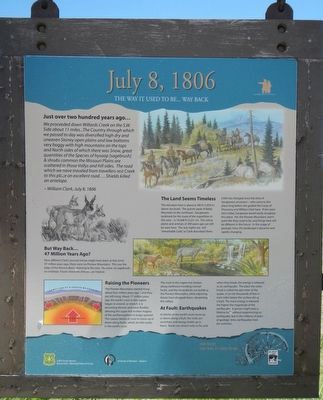
We proceeded down Willards Creek on the S.W. Side about 11 miles...The Country through which we passed to day was diversified high dry and uneaven Stoney open plains and low bottoms very boggy with high mountains on the tops and North sides of which there was Snow, great quantities of the Species of hyssop (sagebrush) & shrubs common the Missouri Plains are scattered in this Valleys and hill sides. The road which we have traveled from travellers rest Creek to this place an excellent road. ...Shields killed an antelope. -- William Clark, July 8, 1806
The elevation here is about 6,100 feet (1,859 m above sea level). The granite peak of Baldy Mountain to the northeast - Sacajawea's landmark for the route of the expedition in this area - is 10,568 ft (3,221 m). The native plants and animals of 200 years ago can still be seen here. The July nights are still "remarkably Cold," as Clark described them. Little has changed since the time of Sacajawea's ancestors - who came to this place long before she guided the Corps of Discovery and William Clark here. If she were here today, Sacajawea would easily recognize this place. Yet, the Pioneer Mountains aren't quite like they used to be, and things here will be different in the future. In the scope of geology time, this landscape is dynamic and rapidly changing.
How different Clark's journal entries might have been at that time! 47 million years ago, there were no Pioneer Mountains. This was the edge of the Renova Basin, draining to the east. No snow, no sagebrush, no antelope. Fossils show the climate was tropical.
The Pioneer Mountains started rising about four million years ago - and they are still rising. About 17 million years ago, the earth's crust in this region began to extend, or stretch. It is becoming thinner and more flexible, allowing the super-hot molten magma of the aesthenosphere (sic) to bulge upward. This causes blocks of crust to move up or down along faults, which are like cracks in the earth's crust.
The crust in this region has broken along northwest-trending normal faults, and the rising blocks are building the Pioneer Mountains, while adjoining blocks have dropped down, deepening the valleys.
As blocks of the earth's crust move

Photographed By Barry Swackhamer, May 12, 2018
2. Welcome to The Pioneer Mountains National Forest Scenic Byway panel
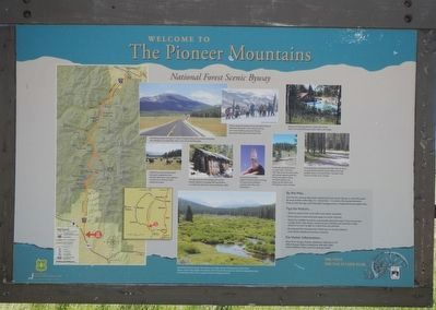
Captions: (left) Map of Pioneer Mountains National Forest Scenic Byway; (small photos, clockwise from upper left) The byway through 43 miles of Pioneer Mountains scenery including this meadow at Crystal Peak, with a view of Comet Mountain; Winter along the byway brings downhill skiing at Maverick Mountain, cross-country skiing, and snowmobiling along Pioneer Mountain National Snowmobile Trail.; Elkhorn Hot Springs Resort is open year round, with a hot spring-fed pool, rustic cabins, and lodge.; Nine developed campgrounds offer sites for tents, or recreational vehicles, picnic tables, fire rings, potable water, and vaulted toilets. Camper may stay at a site for up to 16 days.; Trailheads along the byway connect with more than 250 miles of backcountry trails with varied opportunities for hiking, horseback riding, mountain biking, and exploring the forest with off-highway motor vehicles. Crystal Park provides opportunities to picnic and dig for quarts crystals, from May 16 to December 1.; The ghost town of Coolidge, part of the historic Elkhorn-Coolidge Mining District, is a half-mile hike from Forest Road No. 2465.; Cattle from local ranches graze the open rangeland of the Pioneer Mountains and cowboys at work are a common sight along the byway.; (bottom center) Grand Vista features picnic sites and an accessible trail to a fishing dock on White River. Stories of the land, people and animals of the Pioneer Mountains are retold in interpretive signs at Grand Vista and at other wayside locations along the byway.
Erected by USDA Forest Service, University of Montana - Western.
Topics and series. This historical marker is listed in these topic lists: Environment • Exploration • Natural Features • Roads & Vehicles. In addition, it is included in the Lewis & Clark Expedition series list. A significant historical date for this entry is July 8, 1806.
Location. 45° 16.872′ N, 113° 7.338′ W. Marker is near Polaris, Montana, in Beaverhead County. Marker is on Pioneer Mountains National Forest Scenic Bywayt (Forest Road 73) near State Highway 278, on the right when traveling north. Touch for map. Marker is in this post office area: Polaris MT 59746, United States of America. Touch for directions.
Other nearby markers. At least 8 other markers are within 10 miles of this marker, measured as the crow flies. "I now take my leave..." (approx. 6˝ miles away); Welcome to Hamilton Ranch (approx. 6.8 miles away); "Hot Spring Valley" (approx. 6.8 miles away); A Soul-Searching Birthday (approx. 6.8 miles away); "The Carroll Ranch" (approx. 6.8 miles away); Naturally Sustained Productivity (approx. 6.8 miles away); Undaunted Stewardship (approx. 6.9 miles away); The First Electric Gold Dredge (approx. 9.7 miles away).
Also see . . . Tours - Pioneer Mountains Scenic Byway - U.S. Forest Service. The Pioneer Mountains Scenic Byway, designated in 1989, cuts through the middle of the Pioneer Mountains in Southwest Montana's Beaverhead County. The route goes from the town of Wise River, south along the stream of the same name, and then crosses into the historic valley formed by Grasshopper Creek. (Submitted on October 5, 2018, by Barry Swackhamer of Brentwood, California.)
Credits. This page was last revised on October 5, 2018. It was originally submitted on October 5, 2018, by Barry Swackhamer of Brentwood, California. This page has been viewed 315 times since then and 27 times this year. Photos: 1, 2, 3. submitted on October 5, 2018, by Barry Swackhamer of Brentwood, California.

