King William in King William County, Virginia — The American South (Mid-Atlantic)
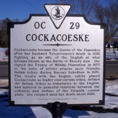
Cockacoeske
Erected 2005 by Department of Historic Resources. (Marker Number OC-29.)
Topics and series. This historical marker is listed in these topic lists: Colonial Era • Native Americans • Women. In addition, it is included in the Virginia Department of Historic Resources (DHR) series list. A significant historical year for this entry is 1656.
Location. 37° 40.797′ N, 77° 0.338′ W. Marker is in King William, Virginia, in King William County. Marker is at the intersection of King William Road (Virginia Route 30) and Powhatan Trail (Virginia Route 633), on the right when traveling east on King William Road. Touch for map. Marker is in this post office area: King William VA 23086, United States of America. Touch for directions.
Other nearby markers. At least 8 other markers are within walking distance of this marker. Pamunkey Indians (here, next to this marker); King William Courthouse (approx. 0.6 miles away); King William County Courthouse (approx. 0.7 miles away); a different marker also named King William Courthouse (approx. 0.7 miles away); King William Confederate Monument (approx. 0.7 miles away); King William County Colonial Court House (approx. 0.7 miles away); Henry Fox (approx. 0.7 miles away); Henry Jenner Jones (approx. 0.7 miles away). Touch for a list and map of all markers in King William.
Also see . . .
1. Pamunkey Indian Tribe Homepage. (Submitted on December 25, 2009.)
2. Cockacoeske. Wikipedia (Submitted on December 25, 2009.)
3. Cockacoeske. Encyclopedia Virginia (Submitted on December 25, 2009.)
Credits. This page was last revised on November 9, 2021. It was originally submitted on December 25, 2009, by Bernard Fisher of Richmond, Virginia. This page has been viewed 1,779 times since then and 61 times this year. Photos: 1, 2. submitted on December 25, 2009, by Bernard Fisher of Richmond, Virginia.

