Near Spotsylvania Courthouse in Spotsylvania County, Virginia — The American South (Mid-Atlantic)
Chancellorsville Campaign

Photographed By Craig Swain, November 10, 2007
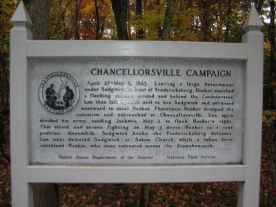
1. Chancellorsville Campaign Marker
This and many similar aluminum markers like it around Fredericksburg, Chancellorsville, the Wilderness, and Spotsylvania Battlefields were erected in the 1950s. Locally these are called "Happel panels" after Ralph Happel, a historian who wrote the text.
April 27-May 6, 1863. Leaving a large detachment under Sedgwick in front of Fredericksburg, Hooker marched a flanking column around and behind the Confederates. Lee then left a small unit to face Sedgwick and advanced westward to meet Hooker. Thereupon, Hooker dropped the initiative and entrenched at Chancellorsville. Lee again divided his army, sending Jackson, May 2, to flank Hooker's right. That attack and severe fighting on May 3 drove Hooker to a rear position. Meanwhile, Sedgwick broke the Fredericksburg defenses. Lee next defeated Sedgwick at Salem Church, while a token force contained Hooker, who soon retreated across the Rappahannock.
Erected by United States Department of the Interior - National Park Service.
Topics and series. This historical marker is listed in this topic list: War, US Civil. In addition, it is included in the Battlefield Trails - Civil War series list. A significant historical date for this entry is April 27, 1863.
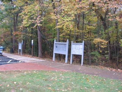
Location. This marker has been replaced by another marker nearby. 38° 18.687′ N, 77° 38.954′ W. Marker is near Spotsylvania Courthouse, Virginia, in Spotsylvania County. Marker can be reached from Plank Road / Germania Highway (State Highway 3), on the right when traveling west. Located in front of the entrance to the Chancellorsville Visitors Center to the Fredericksburg & Spotsylvania National Military Park. Touch for map. Marker is at or near this postal address: 9001 Plank Road, Spotsylvania VA 22553, United States of America. Touch for directions.
Other nearby markers. At least 8 other markers are within walking distance of this location. Chancellorsville (here, next to this marker); Fredericksburg and Spotsylvania National Military Park (a few steps from this marker); a different marker also named Chancellorsville Campaign (within shouting distance of this marker); A Fatal Reconnaissance (within shouting distance of this marker); Confederate Catastrophe (within shouting distance of this marker); a different marker also named Chancellorsville Campaign (within shouting distance of this marker); The Battle of Chancellorsville (within shouting distance of this marker); a different marker also named Chancellorsville Campaign (about 300 feet away, measured in a direct line). Touch for a list and map of all markers in Spotsylvania Courthouse.
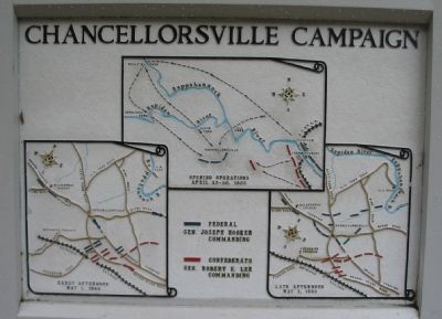
More about this marker. Two relief maps are co-located with the marker, depicting the maneuvers relating to the campaign.
This marker and the two co-located relief maps, were removed in the summer of 2008 as part of the ongoing Park improvements to the interpretive exhibits.
Regarding Chancellorsville Campaign. However, over eighty historical

Photographed By Craig Swain, November 10, 2007
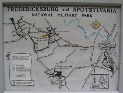
2. Battle Map and Park Tour Map
This map stands to the left of the marker at the edge of the parking lot. Place names important to the battle (and battles!) around Chancellorsville and Fredericksburg are highlighted on the map, overlayed with the locations preserved within the park. Of note, since this map was created, the park has expanded. Visitors are encouraged to get up to date information from the Visitors Center or on line at the Park Service web site.
Related markers. Click here for a list of markers that are related to this marker. Listing of the Trail Heads for Virtual Tours of the Chancellorsville Battlefield.
Also see . . .
1. Battle of Chancellorsville Reference Page. Set of articles, official reports, maps, and orders of battle. (Submitted on November 12, 2007, by Craig Swain of Leesburg, Virginia.)
2. First Day at Chancellorsville Battlefield Virtual tour by Markers. A closer look at the first day battlefield, across ground opened by the Civil War Preservation Trust. (Submitted on September 13, 2008, by Craig Swain of Leesburg, Virginia.)
3. McLaws's Line to Catharine Furnace Virtual Tour by Markers. Covering the eastern side of the National Park, this virtual tour includes markers along the Germanna Turnpike (historical Orange Turnpike), McLaws Drive, Furnace Road, Sickles Drive, and East Jackson Trail. The focus is on the early portions of the battle. (Submitted on November 15, 2007, by Craig Swain of Leesburg, Virginia.)
4. Jackson's Flank March and Attack Virtual Tour by Markers. This virtual tour covers the optional Jackson Flank Trail route of the driving tour and concludes at Jackson's Flank Attack (stop 8) of the driving tour, tracing the route of Jackson's march to deliver the decisive attack of the battle. (Submitted on December 8, 2007, by Craig Swain of Leesburg, Virginia.)
5. Wounding of Stonewall Jackson Virtual Tour by Markers. This virtual tour includes markers on the Wounding of Stonewall Jackson walking trail and sites associated with the Jackson's death on May 10, 1863. (Submitted on December 8, 2007, by Craig Swain of Leesburg, Virginia.)
6. Hazel Grove - Fairview Virtual Tour by Markers. The Hazel Grove and Fairview portions of the battlefield (stops nine and ten on the driving tour of the battlefield). Markers along this tour include those on Stuart and Slocum Drives. (Submitted on November 18, 2007, by Craig Swain of Leesburg, Virginia.)
7. Chancellorsville Intersection Virtual Tour by Markers. The Chancellor House and Chancellorsville Intersection portions of the battlefield (stop three on the driving tour of the battlefield). Markers along this virtual tour include those detailing the story of the Chancellors Inn and the fighting in the Chancellor Clearing. (Submitted on December 8, 2007, by Craig Swain of Leesburg, Virginia.)
8. Bullock House Site Virtual Tour by Markers. The Bullock House Site portion of the battlefield (stop two on the driving tour of the battlefield). Markers along this virtual tour include those detailing the story of the Bullock Family and the fighting at Hooker's final line. (Submitted on December 8, 2007, by Craig Swain of Leesburg, Virginia.)
9. 2nd Fredericksburg Battlefield Markers. Virtual Tour by Markers of this section of the Chancellorsville Campaign. (Submitted on October 27, 2008, by Craig Swain of Leesburg, Virginia.)
10. Salem Church Virtual Tour by Markers. The Salem Church site, surrounded by modern development, was an important site in the later stages of the battle. (Submitted on November 12, 2007, by Craig Swain of Leesburg, Virginia.)
11. Chancellorsville History Trail Virtual Tour by Markers. Set of markers along the Chancellorsville History trail, a 3.6 mile loop which starts at the visitor center. (Submitted on October 24, 2008, by Craig Swain of Leesburg, Virginia.)
Credits. This page was last revised on April 8, 2024. It was originally submitted on November 12, 2007, by Craig Swain of Leesburg, Virginia. This page has been viewed 4,384 times since then and 32 times this year. Photos: 1, 2, 3, 4. submitted on November 12, 2007, by Craig Swain of Leesburg, Virginia.

