Sandusky in Lynchburg, Virginia — The American South (Mid-Atlantic)
Sandusky
Hunter's Headquarters
— Battle of Lynchburg —
Inscription.
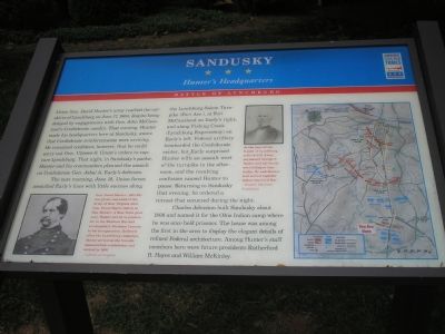
Union Gen. David Hunter’s army reached the outskirts of Lynchburg on June 17, 1864, despite being delayed by engagements with Gen. John McCausland’s Confederate cavalry. That evening, Hunter made his headquarters here at Sandusky, aware that Confederate reinforcements were arriving. He remained confident, however, that he could carry out Gen. Ulysses S. Grant’s orders to capture Lynchburg. That night, in Sandusky’s parlor, Hunter and his commanders planned the assault on Confederate Gen. Jubal A. Early’s defenses.
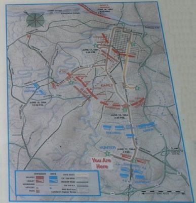
The next morning, June 18, Union forces assaulted Early’s lines with little success along the Lynchburg-Salem Turnpike (Fort Ave.), at Fort McCausland on Early’s right; and along Fishing Creek (Lynchburg Expressway) on Early’s left. Federal artillery bombarded the Confederate center, but Early surprised Hunter with an assault west of the turnpike in the afternoon, and the resulting confusion caused Hunter to pause. Returning to Sandusky that evening, he ordered a retreat that occurred during the night.
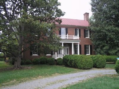
Charles Johnson built Sandusky about 1808 and named it for the Ohio Indian camp where he was once held prisoner. The house was among the first in the area to display the elegant details of refined Federal architecture. Among Hunter’s staff members here were future presidents Rutherford B. Hayes and William McKinley.
Erected by Virginia Civil War Trails.
Topics and series. This historical marker is listed in these topic lists: Native Americans • War, US Civil • Wars, US Indian. In addition, it is included in the Former U.S. Presidents: #25 William McKinley, and the Virginia Civil War Trails series lists. A significant historical month for this entry is June 1847.
Location. 37° 22.807′ N, 79° 11.778′ W. Marker is in Lynchburg, Virginia. It is in Sandusky. Marker is on Sandusky Drive, on the left when traveling west. This marker is at historic Sandusky, on Sandusky Drive, 1/3 mile west of US BUS 460. Touch for map. Marker is at or near this postal address: 757 Sandusky Drive, Lynchburg VA 24502, United States of America. Touch for directions.
Other nearby markers. At least 8 other markers are within walking distance of this marker. Lynchburg (here, next to this marker); To The Memory Of The Union Soldiers (a few steps from this marker); Quaker Meeting House (approx. half a mile away); a different marker also named Sandusky (approx. half a mile away); a different marker also named Quaker Meeting House (approx. half a mile away); 91st Ohio Volunteer Infantry (approx. 0.6 miles away); West Virginia Memorial (approx. 0.6 miles away); Grave of John Lynch (approx. 0.6 miles away). Touch for a list and map of all markers in Lynchburg.
More about this marker. In the right center a portrait of George Hutter carries the caption, "At the time of the Battle of Lynchburg, retired U.S. Army paymaster George C. Hutter and his family were living at Sandusky. He and Hunter had served together before the Civil War."
On the lower left next to his portrait is this short biography of General Hunter: Gen. David Hunter (1802-86) was given command of the Army of West Virginia after Gen. Franz Sigel’s defeat at New Market. A West Point graduate, Hunter served as paymaster in the Mexican War and accompanied Abraham Lincoln to his inauguration. Relieved after the Lynchburg campaign, Hunter served on the Lincoln assassination commission and retired in 1866.
A map showing the unit dispositions during the battle is on the right side.
Regarding Sandusky. This is one in a series of Civil War Trails markers interpreting the Battle of Lynchburg (17-18 June 1864) and the city's role in the Civil War. Select the Civil War Virtual Tour by Marker link below to see other related markers.
Also see . . .
1. Historic Sandusky Foundation. (Submitted on December 3, 2007, by Craig Swain of Leesburg, Virginia.)
2. Civil War Lynchburg Virtual Tour by Markers. An eight stop Civil War Trails tour, with several Virginia state markers and other
memorials added. (Submitted on December 8, 2007, by Craig Swain of Leesburg, Virginia.)
Credits. This page was last revised on February 1, 2023. It was originally submitted on December 2, 2007, by Bill Coughlin of Woodland Park, New Jersey. This page has been viewed 2,674 times since then and 95 times this year. Photos: 1, 2, 3. submitted on December 2, 2007, by Bill Coughlin of Woodland Park, New Jersey. • Craig Swain was the editor who published this page.


