Jefferson City in Cole County, Missouri — The American Midwest (Upper Plains)
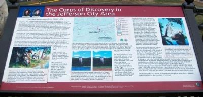
The Corps of Discovery in the Jefferson City Area
Inscription.
On June 4, 1804, a keelboat and two pirogues containing the members of the Corps of Discovery passed this spot as they headed upstream to the headwaters of the Missouri River and across the Rocky Mountains to the Pacific Ocean. The Lewis and Clark Expedition was in the twenty-second day of their two-year, four month long odyssey. Already fighting the strong currents of the Missouri River, the party had managed to cover over 145 miles since leaving their Winter encampment at the River DuBois, in present day Illinois. The expedition still had 3,855 hard miles stretching ahead before they reached their destination on the western rim of the continent.
At the time the Corps passed the future site of Missouri's capital, the detachment consisted of 45 men, including the members of the "Captain's Mess," depicted in the statuary group. There were also 24 American soldiers crewing the Keelboat. They were under three sergeants. Eight French-Canadian engagés manned the red pirogue, and six privates and a corporal were pulling at the oars of the white pirogue.
On June 3, the party left their camp of three days at the mouth of the Osage River, where they had taken measurements and scientific observations. They moved five miles upstream to the mouth of the Moreau River. There, Capt. William Clark heard a bird singing all night that he did not recognize. He named a small creek Nightingale Creek in honor of this mystery bird.
Clark noted in his journal: "I Saw much Sign of war parties of Indians having Crossed from the mouth of this Creek."
This seemed to confirm a report Clark had heard five days earlier, in St. Charles that war parties of Sauk and Fox Indians had recently crossed the river to war against the mighty Osage Indian Tribe.
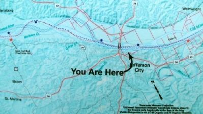
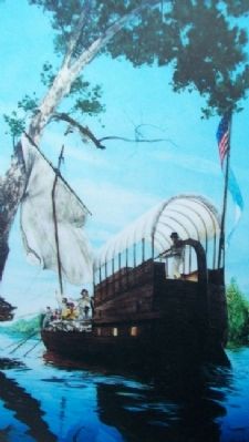
After leaving three hunters on the north shore of the river, the party pushed into the current, following the river as it turned in a northwest direction. They passed Cedar Island, named for the thick stand of eastern red cedar that grew there. Beyond and nearly opposite the present Capitol, Cedar Creek entered the river. Past Cedar Creek, the mast of the 55-foot long keelboat broke after it became entangled in the limbs of a sycamore tree that leaned over the channel.
The men in the boats were impressed with the beauty of the country that lay on both sides of the river. Clark observed: "Fine land above and below...Delightful Timber of Oake ash walnut hickory &c &c." Sgt. Charles Floyd remarked: A Butifull a peas of Land as ever I saw walnut shoger tree [sugar maple] ash and mulber [mulberry] trees."
As the members of the Expedition neared the end of their 17.5-mile day they passed a creek that Clark called "Zoncar." A later
Photographed By Michael Haynes, undated
2. Image on The Corps of Discovery in the Jefferson City Area Marker
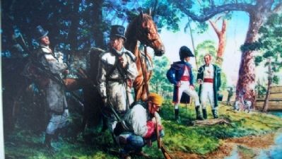
[Caption reads] This painting by Michael Haynes depicts George Drouillard, the expedition hunter and interpreter, examining Indian sign while Capts. William Clark and Meriwether Lewis confer. Two expedition members prepare to hunt. The clothing worn by the men in the painting is accurate to the time period of the expedition, according to careful research conducted by the artist.
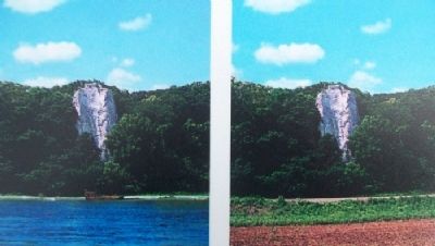
Clark hiked through the rush bottom, which he found "charming," for a mile and then through a last stretch of chest high nettles before coming to the base of "Lead Mine Hill." He did not find any lead deposits, as he ascended to the top of the hill, which he estimated to be 170 feet in height. At the top he saw a six-foot high Indian mound. Such mounds, in this area, commonly date to the Late Woodland Period, ca. 400-900 A.D. Clark also saw a hundred acres of dead timber. Clark descended the steep river side of the hill about 50 feet to a semi-circle of shelter caves - he described them as "encompassing," "verry extensive." From here he could go out on to the top of Sugar Loaf Rock, which at that time "Spured up and hung over the Water...from the top of this rock I had
Photographed By MO Dept of Natural Resources, undated
3. Image on The Corps of Discovery in the Jefferson City Area Marker
[Caption reads] The digitally altered photograph (above left) of Sugar Loaf Rock depicts how it might have looked at the time of the expedition camped there on June 4, 1804, when the Missouri River flowed at it's [sic] base. The photograph to the right shows the once well known river landmark as it looks today, at the edge of a wide floodplain.
The hunters who had set out in the morning brought in seven deer, a dramatic improvement over previous days of hunting.
Erected by Missouri Department of Natural Resources.
Topics and series. This historical marker is listed in these topic lists: Exploration • Native Americans • Waterways & Vessels. In addition, it is included in the Lewis & Clark Expedition series list. A significant historical month for this entry is June 1867.
Location. 38° 34.708′ N, 92° 10.282′ W. Marker is in Jefferson City, Missouri, in Cole County. Marker is at the intersection of Jefferson Street and Capitol Avenue, on the left when traveling north on Jefferson Street. Marker is at the Lewis and Clark Trailhead Plaza. Touch for map. Marker is in this post office area: Jefferson City MO 65101, United States of America. Touch for directions.
Other nearby markers. At least 8 other markers are within walking distance of this marker. The Missouri River Valley as a Transportation Corridor (here, next to this marker); Corps of Discovery (a few steps from this marker); Jefferson City Greenway: (within shouting distance of this marker); Replica of the Statue of Liberty (about 300 feet away, measured in a direct line); Thomas Jefferson
Photographed By Michael Haynes, undated
4. Image on The Corps of Discovery in the Jefferson City Area Marker
[Caption reads] With Sgt. John Ordway at the helm, the keelboat was steered to close to an overhanging sycamore tree that caught the mast and broke it. Clark named a nearby creek, today's Gray's Creek, "Mast Creek" in recognition of the mishap.
Also see . . .
1. Follow In The Footsteps Of Missouri’s First Explorers On This Adventurous Road Trip. Only In Your State website entry (Submitted on January 5, 2013, by William Fischer, Jr. of Scranton, Pennsylvania.)
2. Lewis and Clark Across Missouri. Website homepage (Submitted on January 5, 2013, by William Fischer, Jr. of Scranton, Pennsylvania.)
3. Lewis and Clark National Historical Trail. National Park Service website entry (Submitted on January 5, 2013, by William Fischer, Jr. of Scranton, Pennsylvania.)
Credits. This page was last revised on April 30, 2022. It was originally submitted on January 5, 2013, by William Fischer, Jr. of Scranton, Pennsylvania. This page has been viewed 829 times since then and 24 times this year. Photos: 1, 2, 3, 4, 5, 6. submitted on January 5, 2013, by William Fischer, Jr. of Scranton, Pennsylvania. 7. submitted on January 4, 2013, by William Fischer, Jr. of Scranton, Pennsylvania.
