James Bay in Victoria in Capital, British Columbia — Canada’s West Coast (North America)
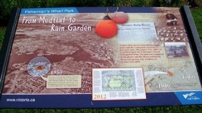
From Mudflat to Rain Garden
Fisherman's Wharf Park
A sports field served James Bay for many years until the Community envisioned a new park space. On August 27th, 2009 City Council adopted the Fisherman's Wharf Management Plan. The plan was completed in two phases and the Mayor celebrated the grand opening with residents on October 2nd, 2012.
[Inset photos and text follow]
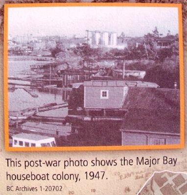
A small shanty-town was also born during this era with houses in the bay. 1940's.
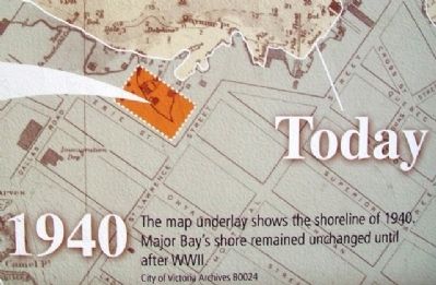
1940 - Today
The map underlay shows the shoreline of 1940. Major Bay's shore remained unchanged until after WWII.
City of Victoria Archives B0024
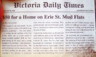
Victoria Daily Times, August 29, 1942
$50 for a Home on Erie St. Mud Flats
by Iris Smallwood
"We bought it", she said simply. "It cost $50 too, but it is worth it. We can fix it up pretty by wintertime."... The 'new house'... is settling into the mudflats at the foot of Erie Street, one of a little crowd of shacks huddled together. With her husband serving in the navy, and a young daughter to be schooled,... (she) had hitch-hiked down from an up-island farm... We spoke of the war, and the nearest schools, and berry picking on the farm... After snapping a few pictures, I clambered down from the rickety houseboat. They smiled broadly and waved friendly goodbyes as I promised to return with a picture for each of them.
I parted the bushes back on the trail and came suddenly upon a very old man dozing in front of a little lean-to... Here he has lived for 28 years, first in a fine, large houseboat, he explained... It occurred to me that there was no water supply. I asked him how he managed. He... said, pointing over the water half a mile away: "I row over to the Shell Oil building. They have a tap there and don't bother us much. I get a pailful of water now and then,"... fishing morning and evening, working on his boat during the day, such is the pleasant life of an ex-mounted policeman.
He was burly and good-natured and offered me a cup of tea, but... I declined. The rationing of tea is quite a consideration but little enough inconvenience compared to lack of water... I left feeling strongly the air of friendliness, candor and almost self-sufficiency about this little amphibian colony..."
This post-war photo shows the Major Bay houseboat colony, 1947.
BC Archives 1-20702
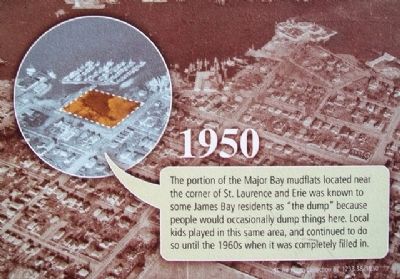
1950
The portion of the Major Bay mudflats located near the corner of St. Laurence and Erie was known to some James Bay residents as "the dump" because people would occasionally dump things here. Local kids played in this same area, and continued to do so until the 1960s when it was completely filled in.
BC Air Photo Collection BC 1233:38, 1950
Randy used to collect beach worms in the mud flats to use as bait for his fishing adventures near Ogden point. 1954.
Image: Courtesy of Randy Bouchard
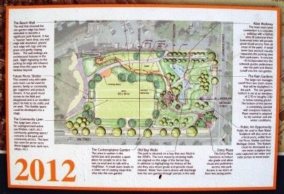
2012
The Beach Wall
The wall that retained the rain garden edge has been extended to become a significant park feature. It has a 'riparian' back drop, sea wall edge (old shoreline), gravel/rock edge with logs and sea grass and gently sloping lawns. The wall endings are architectural features in the park. Slight regrading on the parking lot edge will enhance views from this space to the harbour beyond.
Future Picnic Shelter
This covered area with table and chairs can be used for picnics, family or community get-togethers and potluck dinners. It has good visual access to the field and playground and is an excellent place for kids to do crafts and art work. This flexible space could be developed into a stage.
The Community Lawn
This large lawn area is for unprogrammed active use (frisbee, catch, etc.), community gathering space/concerts in the park and community picnics. The lawn has room for picnic races (three legged race, sack race, relays, etc.).
The Contemplative Garden
This area is sunken in the landscape and provides a quiet place for people to sit in the sun, to read and to talk with a neighbour. A small stairs leads to a lower set of seating steps that step into the rain garden.
Old Bay Walls
The park is situated on a bay that was filled in the 1950's. The rock masonry retaining walls are aligned on the edge of the former bay. In addition to highlighting the history of the site they also retain grade and provide visual interest. Water from storm drains will discharge into the rain garden through portals in the wall.
Entry Plaza
The Entry Plaza functions to reduce site grade and allow visual and pedestrian access into park. Access is via stairs or from two arcing paths.
Allee Walkway
The main east/west connection is a concrete walkway with a formal allee of columnar trees (columnar trees will provide good visual access from all areas of the park). A small berm (see section) visually separates the parking area from park users. A concave rill incorporated into the sidewalk guides pedestrians into the park and directs runoff into the rain gardens.
The Rain Gardens
The large rain [garden] manages runoff from two storm drains that will be daylighted in the park. The rain garden bottom is set at an elevation of 2.70m (roughly 3.50m below existing grade). The bottom of the planter is completely planted with evergreen material. Plant material is adapted to dry summer and wet winter conditions.
Public Art Opportunity
Public
Art and/or Rain Water Sculpture will also serve as a focal point, visible from the Picnic Shelter and from Michigan Street. This feature could be developed as a rain water sculpture that uses captured rain water and solar pumps to move water.
www.victoria.ca
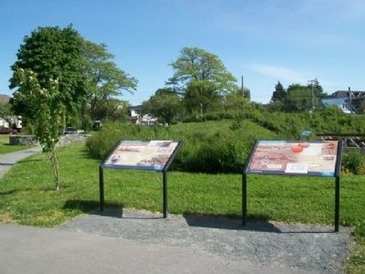
Erected by City of Victoria.
Topics. This historical marker is listed in these topic lists: Environment • Parks & Recreational Areas • Sports • Waterways & Vessels. A significant historical date for this entry is October 2, 2012.
Location. 48° 25.304′ N, 123° 22.916′ W. Marker is in Victoria, British Columbia, in Capital. It is in James Bay. Marker is near the eastern edge of Fisherman's Wharf Park, near the car park accessed off St. Lawrence Street. Touch for map. Marker is in this post office area: Victoria BC V8V 0B2, Canada. Touch for directions.
Other nearby markers. At least 8 other markers are within walking distance of this marker. A Natural Harbour (here, next to this marker); Pendray House (approx. half a kilometer away); Juan Francisco de la Bodega y Quadra (approx. 0.6 kilometers away); Canadian Pacific Marine Terminal Building (approx. 0.8 kilometers away); The Mackenzie Papineau Battalion of the International Brigades (approx. 0.8 kilometers away); Creation of the Province of British Columbia (approx. 0.8 kilometers away); In Commemoration of the Treaty Between Great Britain and the Russian Empire (approx. 0.8 kilometers away); Esquimalt and Nanaimo Railway Roundhouse (approx. 0.8 kilometers away). Touch for a list and map of all markers in Victoria.
Credits. This page was last revised on March 31, 2024. It was originally submitted on June 13, 2014, by William Fischer, Jr. of Scranton, Pennsylvania. This page has been viewed 518 times since then and 9 times this year. Photos: 1. submitted on June 14, 2014, by William Fischer, Jr. of Scranton, Pennsylvania. 2. submitted on June 13, 2014, by William Fischer, Jr. of Scranton, Pennsylvania. 3, 4, 5, 6, 7. submitted on June 14, 2014, by William Fischer, Jr. of Scranton, Pennsylvania.
