Florence in Lauderdale County, Alabama — The American South (East South Central)
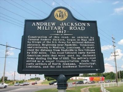
Andrew Jackson's Military Road
1817
Erected by Florence Historical Board, Florence Alabama.
Topics and series. This historical marker is listed in these topic lists: Native Americans • Notable Events • Roads & Vehicles • War of 1812. In addition, it is included in the Former U.S. Presidents: #07 Andrew Jackson series list. A significant historical month for this entry is May 1817.
Location. 34° 50.612′ N, 87° 38.787′ W. Marker is in Florence, Alabama, in Lauderdale County. Marker is at the intersection of County Route 47 and Cox Creek Parkway on County Route 47. Located next to Deibert Park and across the highway from Martins Department Store. Touch for map. Marker is in this post office area: Florence AL 35630, United States of America. Touch for directions.
Other nearby markers. At least 8 other markers are within 3 miles of this marker , measured as the crow flies. Deibert Park (approx. ¼ mile away); Larimore Home (approx. 0.8 miles away); Governor Hugh McVay Home Site and Cemetery (approx. 0.8 miles away); Wilson Family Cemetery 19th Century / Slave Cemetery 19th Century (approx. 1.1 miles away); Sweetwater (approx. 1.3 miles away); Weeden Heights (approx. 1.7 miles away); Veterans Memorial Park (approx. 2.3 miles away); General John Coffee (approx. 2.4 miles away). Touch for a list and map of all markers in Florence.
Credits. This page was last revised on August 4, 2020. It was originally submitted on March 13, 2010, by Sandra Hughes Tidwell of Killen, Alabama, USA. This page has been viewed 3,224 times since then and 96 times this year. Last updated on January 17, 2015, by J. Makali Bruton of Accra, Ghana. Photo 1. submitted on March 13, 2010, by Sandra Hughes Tidwell of Killen, Alabama, USA. • Bernard Fisher was the editor who published this page.
Editor’s want-list for this marker. A wide shot of the marker and its surroundings. • Can you help?
