Melchor de Mencos, Petén, Guatemala — Central America
Yaxhá
(Agua Verde Azul)
— Land of Blue Green Water —
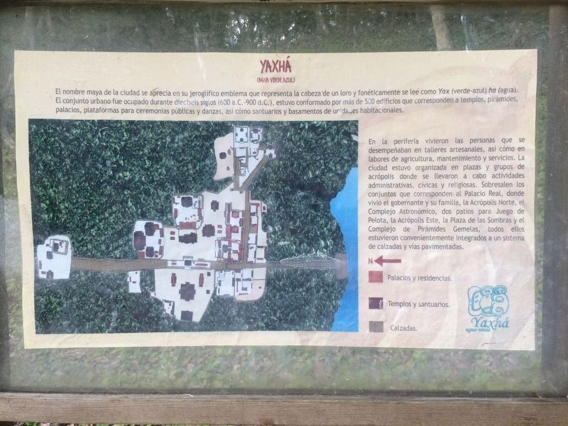
El nombre maya de la ciudad se aprecia en su jeroglífico emblema que representa la cabeza de un loro y fonéticamente se lee como Yax (verde-azul) ha (agua). El conjunto urbano fue ocupado durante dieciséis siglos (600 a.c. - 900 d.c.), estuvo conformado por más de 500 edificios que corresponden a templos, pirámides, palacios, plataformas para ceremonias públicas y danzas, así como santuarios y basamentos de unidades habitacionales.
En la periferia vivieron las personas que se desempeñaban en talleres artesanales, así como en labores de agricultura, mantenimiento y servicios. La ciudad estuvo organizada en plazas y grupos de acrópolis donde se llevaron a cabo actividades administrativas, cívicas y religiosas. Sobresalen los conjuntos que corresponden al Palacio Real, donde vivió el gobernante y su familia, la Acrópolis Norte, el Complejo Astronómico, dos patios para Juego de Pelota, la Acrópolis Este, la Plaza de las Sombras y el Complejo de Pirámides Gemelas, todos ellos estuvieron convenientemente integrados a un sistema de calzadas y vías pavimentadas.
Leyenda de mapa: Palacios y residencias · Templos y santuarios · Calzadas
The Mayan name of the city is seen in its emblem hieroglyph depicting the head of a parrot and phonetically reads like Yax (green-blue) ha (water). The urban area was occupied for sixteen centuries (600 BC - 900 AD). It consisted of more than 500 buildings that corresponded to temples, pyramids, palaces, platforms for public ceremonies and dances, as well as sanctuaries and the foundations of housing units.
On the outskirts lived the people who worked in craft workshops, as well as those that provided agricultural work, maintenance and services. The city was organized into squares and Acropolis groups which were used to carry out administrative, civic and religious activities. The best known examples can be seen in the Royal Palace, where the ruler and his family lived, the North Acropolis, the Astronomic Complex, two Ball Courts, the East Acropolis, the Plaza of Shadows and the Twin Pyramid Complex, all conveniently integrated into a system of causeways and paved roads
Map legend: Palaces and residences · Temples and shrines · Causeways
Topics. This historical marker is listed in these topic lists: Anthropology & Archaeology • Architecture • Man-Made Features • Native Americans.
Location.
17° 4.226′ N, 89° 23.966′ W. Marker is in Melchor de Mencos, Petén. The marker is just inside to the right of the Yaxhá Archaeological Park entrance. The park is some 5 kilometers north of the village of El Zapote, turning from the CA13 road. Touch for map. Marker is in this post office area: Melchor de Mencos, Petén 17011, Guatemala. Touch for directions.
Other nearby markers. At least 8 other markers are within walking distance of this marker. Minor Astronomical Complex at Yaxhá (a few steps from this marker); Plaza of the Columns (about 120 meters away, measured in a direct line); The Eastern Acropolis of Yaxhá (about 180 meters away); The Quarry Causeway (about 180 meters away); East Causeway Residential Zone (approx. 0.3 kilometers away); Intersection of the Eastern and Quarry Causeways (approx. 0.4 kilometers away); Sacrificial Pyramid (approx. half a kilometer away); The Palace's Ballgame (approx. half a kilometer away). Touch for a list and map of all markers in Melchor de Mencos.
Credits. This page was last revised on March 2, 2018. It was originally submitted on October 26, 2016, by J. Makali Bruton of Accra, Ghana. This page has been viewed 294 times since then and 11 times this year. Photos: 1, 2, 3, 4. submitted on October 26, 2016, by J. Makali Bruton of Accra, Ghana.


