Rogersville in Lauderdale County, Alabama — The American South (East South Central)
Lambís Ferry Road
(Side 1)
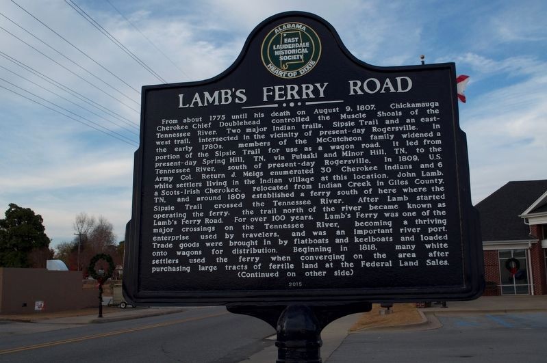
From about 1775 until his death on August 9, 1807, Chickamauga Cherokee Chief Doublehead controlled the Muscle Shoals of the Tennessee River. Two major Indian trails, Sipsie Trail and an east-west trail, intersected in the vicinity of present-day Rogersville. In the early 1780s, members of the McCutcheon family widened a portion of the Sipsie Trail for use as a wagon road. It led from present-day Spring Hill, TN, via Pulaski and Minor Hill, TN, to the Tennessee River, south of present-day Rogersville. In 1809, U.S. Army Col. Return J. Meigs enumerated 30 Cherokee Indians and 6 white settlers living in the Indian village at this location. John Lamb, a Scots-Irish Cherokee, relocated from Indian Creek in Giles County, TN, and around 1809 established a ferry south of here where the Sipsie Trail crossed the Tennessee River. After Lamb started operating the ferry, the trail north of the river became known as Lambís Ferry Road. For over 100 years, Lambís Ferry was one of the major crossings on the Tennessee River, becoming a thriving enterprise used by travelers, and was an important river port. Trade goods were brought in by flatboats and keelboats and loaded onto wagons for distribution. Beginning in 1818, many white settlers used the ferry when converging on the area after purchasing large tracks of fertile land at the Federal Land Sales.
Erected 2015 by East Lauderdale Historical Society.
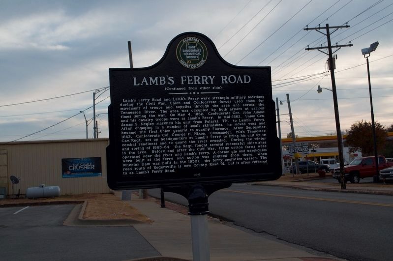
Topics. This historical marker is listed in these topic lists: Native Americans • Roads & Vehicles • War, US Civil. A significant historical date for this entry is May 4, 1862.
Location. 34° 49.513′ N, 87° 17.655′ W. Marker is in Rogersville, Alabama, in Lauderdale County. Marker is on Wheeler Street/Lambs Ferry Road (Alabama Route 207) south of Lee Street (County Route 66), on the left when traveling south. Marker is in front of Rogersville's Town Hall. Touch for map. Marker is at or near this postal address: 72 Wheeler Street, Rogersville AL 35652, United States of America. Touch for directions.
Other nearby markers. At least 8 other markers are within 3 miles of this marker, measured as the crow flies. Heritage Park (about 500 feet away, measured in a direct line); Rogersville Presbyterian Church in the U.S.A. (approx. 0.2 miles away); Lauderdale County High School 1912 (approx. ľ mile away); East End High School (approx. one mile away); Return of a Native (approx. 1.2 miles away); Samuel Burney: 1763-1849 Revolutionary War Veteran / Burneys Creek/First Creek Wheeler Lake (approx. 1Ĺ miles away); General Joseph Wheeler (approx. 2.3 miles away); Bettie Anne Highway (approx. 2.6 miles away). Touch for a list and map of all markers in Rogersville.
Also see . . .
1. Doublehead:Last Chickamauga Cherokee Chief. From the 1600ís through the early 1800ís, five American Indian tribes claimed the area of the Muscle Shoals which included the Yuchi (Euchean), Creek (Muskogee), Shawnee (Algonquin), Chickasaw (Muskogee), and Cherokee (Iroquois). Doublehead and his Chickamauga warriors would be the last Indians to occupy and control this valuable piece of Tennessee River real estate. Even though there were previous conflicts among the Indian tribes that occupied the area of the Muscle Shoals, Doublehead would work with all of these tribes and form alliances with the remaining remnants to organize the strongest Indian confederacy to ever occupy the Tennessee Valleyís Great Bend. (Submitted on November 26, 2016, by Sandra Hughes Tidwell of Killen, Alabama, USA.)
2. Confederate Generals Brigadier General John Adams. Adams was killed in the Battle of Franklin on November 30, 1864, while leading his regiment in a forceful but unsuccessful attack on Union forces. In the midst of the deadliest fighting around the cotton gin, witnesses recall seeing the conspicuous Adams astride his white steed, Old Charley. Well out in front of his brigade, he dashed towards the Federal lines, seemingly impervious to the hail of bullets. Spurring his mount to jump the parapets, the horse came crashing squarely down on top of them, dead. Adams fell from the horse and into the ditches, his body riddled with nine bullets. Breathing his last, Adams was heard to say; "It is the fate of a soldier to die for his country." (Submitted on November 26, 2016, by Sandra Hughes Tidwell of Killen, Alabama, USA.)
3. Post-war Als Union Gen. James S. Negley. James Scott Negley (December 26, 1826 – August 7, 1901) was an American Civil War General, farmer, railroader, and U.S. Representative from the state of Pennsylvania. He played a key role in the Union victory at the Battle of Murfreesboro. Negley was born in Pittsburgh, Pennsylvania, son of Jacob Negley and Barbara Anne Negley. His sister Sarah married Thomas Mellon. He was educated in public schools, and graduated from the Western University of Pennsylvania (now called the University of Pittsburgh). He served in a volunteer regiment, Company K of the Duquesne Greys, 1st Pennsylvania Volunteers, during the Mexican-American War. After the war, he became a farmer and horticulturist. (Submitted on November 26, 2016, by Sandra Hughes Tidwell of Killen, Alabama, USA.)
Credits. This page was last revised on August 11, 2020. It was originally submitted on November 26, 2016, by Sandra Hughes Tidwell of Killen, Alabama, USA. This page has been viewed 1,518 times since then and 108 times this year. Photos: 1, 2. submitted on November 26, 2016, by Sandra Hughes Tidwell of Killen, Alabama, USA. • Bernard Fisher was the editor who published this page.

