Here you see the two outer gatehouses, one on top of the other. look through the scope to get an idea of the size of the lower gatehouse. It was built at the time of King Asa (908-867 BCE) or King Jehoshaphat (870-867 BCE), and continued in use . . . — — Map (db m132577) HM
The Assyrian army built a huge stone ramp against the city walls. This ramp allowed the attackers to bring up battering rams to breach the wall. The base of the ramp you see here is about 70 meters wide and 16 meters high.
As in other places in . . . — — Map (db m132530) HM
Lachish was situated close to the western border of the Kingdom of Judah, facing the Philistines cities and on the to Egypt. Because of the city’s location, the kings of Judah built particularly strong fortifications for it, including a number of . . . — — Map (db m132608) HM
The palace apparently served as the seat of the city’s governor representing the king of Judah. The huge palace complex from the time of King Hezekiah extended over more than 12.5 dunams (1.25 hectares) and included a large courtyard, a central . . . — — Map (db m132611) HM
The biblical, city of Lachish is identified with the archaeological mound you see before you, on the edge of Wadi Lachish, along which ran the main road from the coastal plain to the Hebron Mountains.
Settlement began here in the Neolithic . . . — — Map (db m132634) HM
In this room some 20 potsherds were discovered, bearing inscriptions in ink (ostraca) in ancient Hebrew. These letters are dated to the last years before the Babylonian invasion of the Land of Israel (beginning of the sixth century BCE).
The . . . — — Map (db m132606) HM
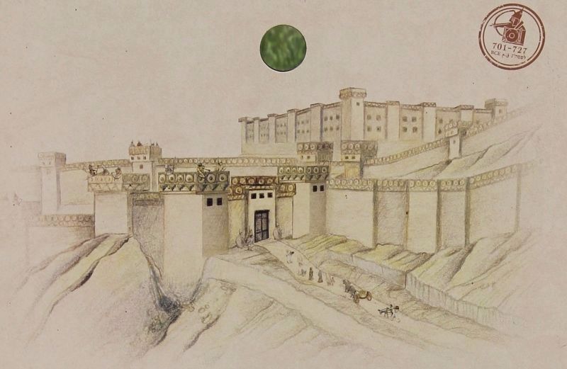
The entrance to the fortified city from the time of the kings of Judah was via an impressive gateway enclosure consisting of an outer and an inner gatehouse, between which was an open paved plaza.
The gateway was the beating heart of the city . . . — — Map (db m132598) HM