7 entries match your criteria.
Related Historical Markers
Door County Coastal Byway
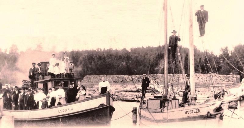
Courtesy of the Sister Bay Historical Society
Marker detail: Employees of Roeser posed for this 1904 photo on company boats
SHOWN IN SOURCE-SPECIFIED ORDER
| On Mill Road (State Highway 42) at Mill Road, on the right when traveling west on Mill Road. |
| | Village life has always revolved around this deep water port.
The community of Sister Bay was born in 1870 when the firm of Henderson, Coon & Dimond built a pier, sawmill, grist mill, hotel, and two stores. They hired Swedish woodchoppers . . . — — Map (db m229454) HM |
| On Mill Road (State Highway 42) at Bay Shore Drive, on the right when traveling west on Mill Road. |
| | Sister Bay was named For the Sister Islands that Flank its harbor. This pair of small uninhabited islands is a significant nesting site for gulls and terns. The Village of Sister Bay offers the largest public waterfront in Door County for . . . — — Map (db m229455) HM |
| On Sunnyside Lane (State Highway 42) 0.1 miles north of Porcupine Bay Road, on the left when traveling north. |
| | The land surrounding you was once owned by John Ellison. Johan Eliason, later known as John Ellison, was a Danish immigrant who founded this community in 1865. He purchased 8,000 acres of land including a mile of shoreline, and advertised in . . . — — Map (db m130477) HM |
| On Sunnyside Lane (State Highway 42) 0.1 miles north of Porcupine Bay Road, on the left when traveling north. |
| | The limestone bluffs you see along Green Bay are part of the same formation that Niagara Falls plunges over in New York. The Niagara Escarpment arches for a thousand miles around the Great Lakes. Lower layers of soft, erodible shale are . . . — — Map (db m130478) HM |
| On Horseshoe Bay Road at Egg Harbor Road (State Highway 42), on the right when traveling south on Horseshoe Bay Road. |
| | Blessed with good farmland and a deep water port, Egg Harbor has thrived since its beginning in 1861. In the early years, Egg Harbor served fishermen, farmers, and lumbermen. It was the first community in Door County to hard surface its road. . . . — — Map (db m130495) HM |
| On State Highway 42 at Forest Road, on the right when traveling north on State Highway 42. |
| | Sevastopol is the heart of Door Peninsula's famous fruit orchards. Swiss immigrant Joseph Zettel planted the first orchard one mile from here in 1862. His State Fair apple exhibit led University of Wisconsin scientists Emmett Golf and Arthur . . . — — Map (db m130496) HM |
| On State Highway 42 at Forest Road, on the right when traveling north on State Highway 42. |
| | Sevastopol orchards thrive in an ideal blend of climate and soils. Lime-rich soils provide essential nutrients for fruit trees. In addition, cool spring temperatures moderated by the waters and ice of Lake Michigan and Green Bay delay blooming. . . . — — Map (db m130498) HM |
Jun. 17, 2024