On West Commercial Street (Federal Highway 64) at South 2nd Street, on the right when traveling east on West Commercial Street.
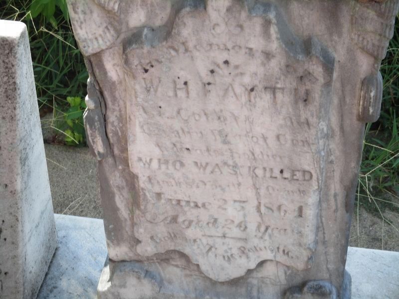
In memory of
W. H. Fayth
Lt. Col. of the Cavalry Regt. of Confederate soldiers
who was killed Amelia Co. Va. on the June 25, 1864
Aged 26 Years
Gallant, True, Patriotic
C.S.A. Killed
Orace Beneux, Virgil Beneux, Derosey . . . — — Map (db m314136) WM
On East River Street east of South 1st Street, on the right when traveling east.
[Stone monument]
Trail of Tears
1832-1840
Arkansas River valley
routes
Choctaw – Chickasaw
Muscogee Creek
Seminole – Cherokee
[Panel]
Trail of Tears Routes through Franklin County
1. Northern Route through . . . — — Map (db m236869) HM
On East Walnut Street (State Highway 22/109) near Airport Industrial Road.
In late September 1863, Confederate Col. J.O. Shelby's cavalry headed north to raid into Missouri. On Sept. 27, 1863, Shelby's scouts found Co. H, 1st Arkansas Infantry (U.S.) camped at Haguewood Prairie near present-day Paris. The Union troops . . . — — Map (db m129518) HM
On East Main Street east of East State Street, on the right when traveling west.
The City of Union was founded in 1825. It was the second county seat of Franklin County, replacing New Port, which served the county from the time it separated from St. Louis County in 1818. In 1859, John T. Vitt constructed the brick building . . . — — Map (db m124309) HM
On Sheridan Road 0.3 miles east of Telegraph Road (Missouri Route 231), on the left when traveling east. Reported missing.
The Jefferson Barracks National Cemetery was established by joint resolution of Congress in 1866, among the first burial grounds officially designated in the wake of the Civil War. Under the care of the Veterans Administration, the facility is . . . — — Map (db m124986) HM
Near West Commercial Street (Highway 64) west of S 2nd Street, on the right when traveling east.
Front Side:
Battery C 2/142 F. A.
Arkansas Army National Guard
and many others from
Franklin County went
They all returned
Right Side:
Dedicated to those
who served
and the community for support . . . — — Map (db m310723) WM
On Green Hill Cemetery Road 0.1 miles east of Atwood Avenue, on the right when traveling north.
Officially, 23,703 African Americans in Kentucky responded to the call to arms by President Lincoln and Frederick Douglass to join the ranks of the newly organized United States Colored Troops. Units were organized with men from across the . . . — — Map (db m84675) HM
The City of Pacific, once known as Franklin, takes its name from the railroad that bustles through town. Up to the time of the Civil War only the Pacific Railroad ran from St. Louis to this point.
The main line of the Pacific Railroad was . . . — — Map (db m168408) HM
On West 8th Street west of Jefferson Street, on the left when traveling west.
The John B. Busch Washington Brewery And Malt House
In about 1854 John Baptiste Busch together with his older brother, Henry Busch, and a friend, Fred Gersie, started the Washington Brewery and Malt House at Jefferson and Eighth Street. John . . . — — Map (db m268728) HM
On West Front Street west of Elm Street, on the right when traveling west.
Washington Railroad Depot Burns
Confederate General Marmaduke's forces were advancing on Washington as October 1864 approached, with fear and widespread panic among the town's residents. Many citizens crossed the river to evade the advance of . . . — — Map (db m239173) HM