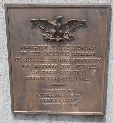
Dedicated to the memory of the patriotic citizens of Russell County, Kentucky who entered the service of their country during the World War — — Map (db m214968) WM
On Orby Cantrell Highway (U.S. 23), on the right when traveling south on Orby Cantrell Highway.
Wise County. Wise County was formed in 1856 from Lee, Scott,
and Russell Counties. It was named for Henry
Alexander Wise who was governor of Virginia
from 1856 to 1860. The county seat is the town
of Wise. After the Civil War the town of . . . — — Map (db m90800) HM
On Old Wilderness Road (Virginia Route 58) 0.2 miles north of Route 872, on the right when traveling west.
Lee County. Lee County, the western-most county in Virginia, was formed from Russell County in 1792; a part of Scott County was added later. The county is named for Henry "Light Horse Harry" Lee, governor of Virginia from 1791 to 1794 and . . . — — Map (db m80237) HM
Near Jerry West Highway (West Virginia Route 44) 0.5 miles south of Philips Street, on the right when traveling south.
Descended from English settlers, the Hatfield clan made its way to western Virginia by the 1770s. The first Hatfield to arrive at Tug Fork Valley was Ephraim, nicknamed "Eph-of-All", from Russell County, Virginia. He and his second wife, Anna . . . — — Map (db m306427) HM
On U.S. 23 0.8 miles south of Jasper Road, on the right when traveling south.
Lee County. Lee County, the western-most county in Virginia, was formed from Russell County in 1792; a part of Scott County was added later. The county is named for Henry “Light-Horse Harry” Lee, governor of Virginia from 1791 to 1794 and . . . — — Map (db m228717) HM
On Haysters Gap Road (Virginia Route 80) at Corn Valley Road (County Route 619) on Haysters Gap Road.
Near this site is the grave of Frances Dickenson
Scott Johnson (died 1796), sister of Henry
Dickenson who was the first clerk of Russell
County. In 1785, while living in Powell’s Valley
in Scott County, her first husband, Archibald
Scott, and . . . — — Map (db m91048) HM
On Clintwood Highway (Virginia Route 83) at the county line, on the right when traveling east on Clintwood Highway.
Wise County. Wise County was formed in 1856 from Lee, Scott,
and Russell Counties. It was named for Henry
Alexander Wise who was governor of Virginia
from 1856 to 1860. The county seat is the town
of Wise. After the Civil War the town of . . . — — Map (db m90775) HM
On Orby Cantrell Highway (U.S. 23) 0.4 miles south of Baxley Lane, on the right when traveling south.
Lee County, the western-most county in
Virginia, was formed from Russell County in
1792; a part of Scott County was added
later. The county is named for Henry “Light-
Horse Harry” Lee, governor of Virginia
from 1791 to 1794 and former . . . — — Map (db m228710) HM
Thin black lines indicate changes in relevance. Between each pair of lines entries are ordered geographically but all have the same relevance.
* Inflectional forms of words are their plurals, singulars, and possessives as well as gramatical tenses and similar variations.