On McCarter Drive (State Highway 418) west of Interstate 385, on the right when traveling west.
[Front]:
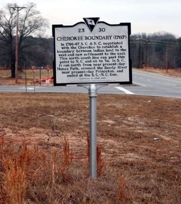
In 1766-67 S.C. & N.C. negotiated with the Cherokee to establish a boundary between Indian land to the west and new settlement to the east. This north-south line ran past this point to N.C. and on to Va. In S.C. it ran north . . . — — Map (db m49086) HM
On Duckett Street at Mount Zion Drive (County Road 89) on Duckett Street.
[Front]:
The Fountain Inn Rosenwald School, also known as the Fountain Inn Colored School, was a complex of several buildings built here from 1928 to 1942. The first school, a frame seven-room elementary school for grades 1-7, was a . . . — — Map (db m50524) HM
On Hickory Tavern Road south of County Road 301, on the left when traveling north.
This house was built by T.C. Bolling c. 1840 near the old Indian boundary. C.B. Stewart, minister of nearby Fairview Presbyterian Church lived here 1859-1890. — — Map (db m239611) HM
On South Highway 14 (State Highway 14), on the left when traveling north.
[Front]:
In 1766-67 S.C. & N.C. negotiated with the Cherokee to establish a boundary between Indian land to the west and new settlement to the east. This north-south line ran past this point to N.C. and on to Va. In S.C. it ran north . . . — — Map (db m8446) HM
This area was settled soon after the Revolution, and a community grew up here on the road from Greenville to Laurens. It was later known as Butler’s Crossroads for Willis W. Butler, who acquired a tract including the intersection of the Laurens . . . — — Map (db m60344) HM
[Front]:
This church, which takes its name from a nearby salt lick, was founded in 1882. Mrs. Ellen C. Woodside (1838-1906) worked with Rev. C.L. Stewart to organize services on her farm in 1880-81. A commission from the Enoree . . . — — Map (db m29455) HM
On North Tigerville Road at Route 414 on North Tigerville Road.
[Front]:
Tigerville got its name from early settlers who settled here shortly after the Revolution. They called bobcats they saw here "tygers," and named the nearby Tyger River, Head of Tyger Baptist Church, later Tyger Baptist Church, . . . — — Map (db m18044) HM