On U.S. 219 at Steven Hole Run Road (County Route 219/8), on the right when traveling south on U.S. 219.
William L. "Mudwall" Jackson and the main body of the 19th Virginia Cavalry were in camp near Mill Point on November 3, 1863, when they received a message from Lt. George W. Siple, a Pocahontas County native in Capt. William L. McNeel's Company F, . . . — — Map (db m34333) HM
On Main Street (U.S. 219), on the right when traveling south.
John D. Sutton, 10th West Virginia Infantry, wrote, "The army went into camp in the levels between Mill Point and Hillsboro." These fields were later owned by 2nd Lt. Matthew John McNeel, Company F, 19th Virginia Cavalry, and the Capt. Edgar . . . — — Map (db m34146) HM
On Main Street (U.S. 219) at 2nd Street, on the right when traveling north on Main Street.
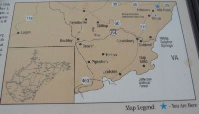
Here Gen. W.W. Averell camped before the Battle of Droop Mountain and after his raid to Salem, Virginia, in 1863. Settlements were made in the vicinity in the 1760s by John McNeel and the Kinnisons. Birthplace of Pearl Buck. — — Map (db m34352) HM
Near Seneca Trail (U.S. 219) near George Hill Road (County Route 24/1).
Originally placed behind a hill to the rear, the 22nd Va. was moved here, in front of the Confederate artillery, where they overlooked the highway. Companies A, E, and I were later detached and sent to reinforce Col. Jackson on the left flank. Both . . . — — Map (db m34383) HM
Near Seneca Trail (U.S. 219) near George Hill Road (County Route 24/1).
From this deep ravine, the 2nd WV battled its way to the mountaintop and was actively engaged in the fighting here at the Confederate center. Lieutenant J. B. Smith, the youngest officer in the regiment, was the first Federal soldier inside the . . . — — Map (db m34389) HM
Near Seneca Trail (U.S. 219) near George Hill Road (County Route 24/1).
The men of the 3rd WV fought their way up this ravine extending their line of battle along the mountainside until they joined with the 28th Ohio. Upon reaching the top, they helped break the Confederate line and pursued the defeated army south . . . — — Map (db m34390) HM
Near Seneca Trail (U.S. 219) near George Hill Road (County Route 24/1).
With help from the Federal artillery, the 8th WV attacked the Confederate center by climbing up the cleared face of this ridge. There they were joined by the 2nd WV, overran the the breastworks and forced the defending Confederates to fall back . . . — — Map (db m34387) HM
Near Seneca Trail (U.S. 219) near George Hill Road (County Route 24/1).
First stationed across the highway and on the extreme right of the Confederate line, the 23rd Battalion was later moved to support the 19th Va. Cavalry on the left flank. After an initial charge that temporarily halted the Federal advance, the 23rd . . . — — Map (db m34391) HM
Near Seneca Trail (U.S. 219) near George Hill Road (County Route 24/1).
Protecting much of the Confederate army were seven artillery pieces, all of which were placed above the highway. Both smoothbore and rifled cannon were present and blocked efforts by the Union army to advance up the main road. However, the position . . . — — Map (db m34385) HM
Near Seneca Trail (U.S. 219) near George Hill Road (County Route 24/1).
This marks the spot where John D. Baxter, Orderly Sergeant, Co. F, 10th W.Va. Inft. Fell inside the Confederate line leading the last charge, November 6th, 1863. — — Map (db m34394) HM
Near Seneca Trail (U.S. 219) near George Hill Road (County Route 24/1).
Commanded Co.F. in the last charge that the 10th W.Va. Vol. Inft. made that broke the Confederate line at the bloody angle, where so many of the brave men of both armies fell, November 6th, 1863. — — Map (db m34395) HM
On Seneca Trail (U.S. 219) 0.2 miles north of Delta Road 18, on the right when traveling north. Reported damaged.
Here, November 6, 1863, Union troops, commanded by Gen. W.W. Averell, defeated Confederate forces under Gen. John Echols. This has been considered the most extensive engagement in this State and the site was made a State park in 1929. — — Map (db m34364) HM
The battle positions of the 14th Penn. Cavalry and the Federal artillery were on the cleared ridge right of the highway about 2/3 mile distant and 600 feet lower in elevation. Throughout the morning, skirmishers and artillery fire from these groups . . . — — Map (db m34354) HM
Near Seneca Trail (U.S. 219) near George Hill Road (County Route 24/1).
Nearly five months after West Virginia was admitted into the Union, the Confederate army of Brigadier General John Echols still occupied the prosperous Greenbrier Valley region of the new state. From its headquarters in Lewisburg, his army was the . . . — — Map (db m34380) HM
Near Seneca Trail (U.S. 219) near George Hill Road (County Route 24/1).
Nearly five months after West Virginia was admitted into the Union, the Confederate army of Brigadier General John Echols still occupied the prosperous Greenbrier Valley region of the new state. From its headquarters in Lewisburg, his army was the . . . — — Map (db m34382) HM