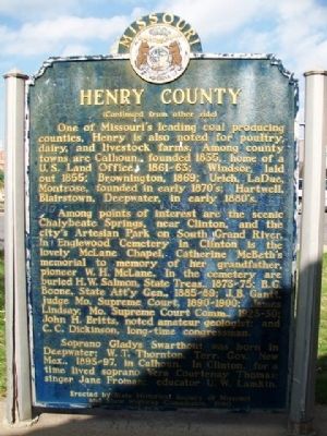
On Washington Street at Franklin Street, on the left when traveling south on Washington Street.
Henry County, in the prairie region of west central Missouri, was organized 1834, and named for Va. statesman William C. Rives. It was renamed for Patrick Henry in 1841, after Rives changed from Democrat to Whig. Through the county, which lies in . . . — — Map (db m69513) HM
Near Price Lane 0.1 miles south of State Route 7/13, on the right when traveling south.
1836........................
Largest City in Henry County
Welcome to Clinton, the largest city in Henry County. The city is named for DeWitt Clinton, governor of New York (1817-23) and primary advocate for the Erie Canal. Henry . . . — — Map (db m252501) HM
Near Katy Trail 0.3 miles west of Oxline Road, on the right when traveling west.
You may not have noticed, but at 955 feet above sea level, you have reached the "summit" of Katy Trail State Park. You are standing on the Osage Plains, named after the Osage people who were once the dominant tribe in western Missouri. At . . . — — Map (db m272490) HM
On Price Lane 0.1 miles south of State Route 7/13, on the right when traveling south.
Depending on your preference, you are either at the beginning or end of your journey in Katy Trail State Park. From this point, the state park and Katy right of way continue for 238 miles to Machens.
If you have just completed your journey . . . — — Map (db m252493) HM
On West Wood Street (Tennessee Route 69) at South Market Street (U.S. 641), on the left when traveling west on West Wood Street.
Singer, evangelist and educator Dr. Bobby Jones popularized African-American gospel music on cable television. He became known as the "Ed Sullivan of Gospel Music." His Black Entertainment Television (BET) show, "Bobby Jones Gospel," ran from 1980 . . . — — Map (db m179617) HM
Near Letcher Lane (Virginia Route 749) at Ararat Highway ( Route 773), on the left when traveling west.
After the murder of William Letcher in 1780, the history of the fifteen-hundred-acre farm that would become the birthplace and boyhood home of James Ewell Brown Stuart is complex, in some instances vague and uncertain. Shortly after her husband's . . . — — Map (db m267763) HM
Thin black lines indicate changes in relevance. Between each pair of lines entries are ordered geographically but all have the same relevance.
* Inflectional forms of words are their plurals, singulars, and possessives as well as gramatical tenses and similar variations.