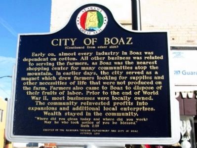
On S Main Street (Alabama Route 205) at Mill Ave ( Highway 168), on the right when traveling north on S Main Street.
Side A Informally called Sparkstown for a period of time, the city of Boaz was officially named after the husband of Ruth, a Biblical character in the Old Testament. Incorporated in March 1897, Boaz quickly began to "set a pace for her . . . — — Map (db m39156) HM
On West Commercial Street (Federal Highway 64) at South 2nd Street, on the right when traveling east on West Commercial Street.
In memory of
W. H. Fayth
Lt. Col. of the Cavalry Regt. of Confederate soldiers
who was killed Amelia Co. Va. on the June 25, 1864
Aged 26 Years
Gallant, True, Patriotic
C.S.A. Killed
Orace Beneux, Virgil Beneux, Derosey . . . — — Map (db m314136) WM
On Blount Avenue 0.1 miles north of Taylor Street, on the right when traveling north.
Montgomery Gilbreath had this board-and-batten house constructed prior to the beginning of the Civil War. Its design is probably based on one of the published house plans of famed landscape gardener and architect A.J. Downing (1815-1852) of . . . — — Map (db m235551) HM
On Lee Street (County Route 66) at Hickory Drive, on the left when traveling west on Lee Street.
Liberty Church. At this location, just west of present-day downtown Rogersville, was the area's first place set aside for Christian worship, circa 1818. Ideally situated alongside the major east-west thoroughfare, this was the closest . . . — — Map (db m266763) HM
On Nashville Highway (Alternate U.S. 31) 0.1 miles north of Warner Road, on the right when traveling north.
Born in Princeton City, Jackson County, Alabama, Horton was an educator and prominent attorney and farmer. He married Anna Adeline Wilhoite on November 25, 1896. Elected to the state legislature from Franklin County in 1907, he represented . . . — — Map (db m151047) HM
On West Main Street (Alabama Route 205) west of Lombardy Street, on the left when traveling west.
Albertville, located in Marshall County in northeast Alabama, was named for Thomas A. Albert, one of the first area residents. It lies on Sand Mountain, a plateau approximately 25 miles wide and 75 miles long. Albertville was hunting ground for . . . — — Map (db m225622) HM
Near Dexter Avenue east of Decatur Street, on the right when traveling east.
Great Depression
The U.S. economy collapsed in late 1929, triggering a
national crisis. Alabama's rural residents had weathered
hardship for decades. Now urban workers and professionals
also faced economic ruin. Businesses closed, factories . . . — — Map (db m182629) HM
On Cathedral Caverns Highway north of 1st Street West, on the left when traveling north.
In 1924, the Alabama Society of the Daughters of the American Revolution (DAR) established Kate Duncan Smith School to provide a patriotic education dedicated to academic achievement and service to "God, Home, and Country" for the people of . . . — — Map (db m33308) HM
On William Street north of West Broadway Street, on the right when traveling south.
Prisoners at Alton Military Prison
The Alton Military Prison was inhabited by four different classes of prisoner, Confederates, civilians, Federal soldiers and a group called guerillas or bushwhackers.
Confederate prisoners of war made up . . . — — Map (db m211487) HM
On County Road 36 0.1 miles north of New Home Church Road, on the right when traveling north.
William M. Bailey (born 1859 in Cherokee Co.; died 1909 in Blount Co.) settled 40 acres on what became Co. Rd 36 to the west and New Home Church Rd to the east in 1893. He brought three small sons from Cherokee Co. after the death of his first wife . . . — — Map (db m42599) HM
On Fry Gap Road (County Route 48) 0.1 miles west of Rock Hill Road, on the right when traveling east.
Located on the hilltop 500 feet southwest of here. Fry Cemetery typifies rural valley-and-ridge community cemeteries of the 1800s. The Fry family emigrated from Virginia to this area when it was still part of the Mississippi Territory. Revolutionary . . . — — Map (db m261863) HM
Thin black lines indicate changes in relevance. Between each pair of lines entries are ordered geographically but all have the same relevance.
* Inflectional forms of words are their plurals, singulars, and possessives as well as gramatical tenses and similar variations.