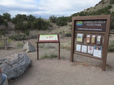
On County Road 59, on the right when traveling south.
… where you will experience the tri-cultural story of New Mexico, a history of the Indians, the Spanish, and the Anglos each altering this landscape in their efforts to obtain turquoise, lead, silver, and more.
Indians mined nearby . . . — — Map (db m70565) HM
On Church Street (State Highway 150) at Byrd Avenue (Farm to Market Road 1514), on the right when traveling north on Church Street.
Born in Georgia and married there in 1837 to Martha Evans Gindrat (1809-63), a widow with 3 children, George T. Wood came to Texas with his family in 1839 and settled along the Trinity River near Point Blank. Wood studied law and was elected to the . . . — — Map (db m118970) HM
On Robinson Way, on the right when traveling south.
Born in Georgia, where he fought in Indian Wars, was a merchant, and member of State Legislature. In 1839, he moved with family to Texas, settling in this area. He was a member of 6th Congress of the Republic of Texas, 1841-1842; a delegate to the . . . — — Map (db m128922) HM
On State Highway 50 0.8 miles east of Interstate 25, on the right when traveling east.
The Civil War battle fought in this pass is often referred to as the "Gettysburg of the West." Union forces dashed Confederate strategy to seize the Southwest’s major supply base at Fort Union; Colorado and California were to be next. The Texas . . . — — Map (db m285811) HM
On Constellation Way north of Riverside Loop, on the right when traveling north.
When you cross the bridge over the Santa Fe River, you join a trail with nearly 500 years of New Mexico history! This part of the Santa Fe River Greenway follows one of North America's most famous early roads - El Camino Real de Tierra Adentro, the . . . — — Map (db m185084) HM
Thin black lines indicate changes in relevance. Between each pair of lines entries are ordered geographically but all have the same relevance.
* Inflectional forms of words are their plurals, singulars, and possessives as well as gramatical tenses and similar variations.