(Front )
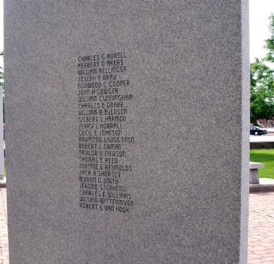
Korean War
Killed in Action
from
Vigo County
( Obverse )
Charles G. Abrell • Herbert D. Akers • William Bellinger • Joseph A. Bray • Norwood C. Cooper • John H. Cowger • William Cunningham • Charles E. Drake • . . . — — Map (db m19794) WM
On Ohio Street south of South 3rd Street, on the left when traveling east.
( Front )
For the Veterans of Vietnam
For the M.I.A.s
For you fallen comrades
For those who came home
For your Heroic efforts abroad
For your Greater efforts at home
With belated acknowledgment
of your duties . . . — — Map (db m19799) WM
( Front )
World War I
Killed in Action
from Vigo County ( Obverse )
Benjamin L. Acree • Earl R. Bailey • Edward Barron • Alva R. Barton • Carl E. Bell • Earl A. Bright • Fred L. Brooks • Anselin G. Brophy • Cyrus E. . . . — — Map (db m19791) WM
( Front )W. W. II
Killed in Action
from Vigo County ( Obverse )
( Row One )
Lawrence Aaren • Ray E. Adams • William H. Altekruse • Charles V. Anderson • Warren C. Anderson • Wayne W. Anderson • Adolph P. Antoine • William . . . — — Map (db m19828) WM
This bridge commemorates the memory of Charles Gene Abrell, Corporal, First Marines of the United States First Marine Division, posthumous holder of the Congressional Medal of Honor. Born August 12, 1931. Died June 10, 1951. — — Map (db m8922) HM
On U.S. 40 at North Seventh Street (Old U.S. 41), on the right when traveling west on U.S. 40.
U.S. Highway 40, the old National Road which opened the West for settlement, and U.S. Highway 41, a major North-South route, were designated part of the original Federal Highway System in 1926. Their intersection in Terre Haute at Wabash Avenue and . . . — — Map (db m8925) HM
On South 3rd Street at East Voorhees Street, on the left when traveling south on South 3rd Street. Reported missing.
World-famous trademark created in 1915 on this site at Root Glass Company, by Chapman J. Root, T. Clyde Edwards, Earl R. Dean, and Alexander Samuelson. Bottle design selected in national competition. — — Map (db m8888) HM
Near North Blackford Street north of Indianapolis Cultural Trail, on the right when traveling north.
Sitting at the junction of the National Road and the Wabash River, Vigo County has played a vital role in the transportation of goods to and from Indiana markets. Terre Haute means "high ground" and reflects early French influence in the area. Paul . . . — — Map (db m238840) HM
On Chestnut Street at North 2nd Street, on the right when traveling west on Chestnut Street.
This marker denotes the site of one of the canal’s dry dock areas as depicted on 1854 City of Terra Haute map.
Dry dock areas along the canal were used to construct and/or repair canal barges and boats.
Constructed mostly of wood . . . — — Map (db m175901) HM
On North Hunt Street at Debney Road, on the right when traveling north on North Hunt Street.
Lost Creek AME
Church 1840
African Methodist
Episcopal Church
Historic Site
The Underground Railroad
Lost Creek, Indiana, prior to the Civil War was a junction of an important line of the Underground Railroad. Slaves fleeing from North . . . — — Map (db m175916) HM
Lynching in America
Following the Civil War, resistance to rights and equality for African
Americans and an ideology of white supremacy led to fatal violence
against Black women, men, and children. Violence spread throughout
the country, . . . — — Map (db m226136) HM
Thin black lines indicate changes in relevance. Between each pair of lines entries are ordered geographically but all have the same relevance.
* Inflectional forms of words are their plurals, singulars, and possessives as well as gramatical tenses and similar variations.