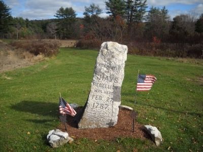
Shays' Rebellion was an armed uprising in Massachusetts during 1786 and 1787 in response to a debt crisis among the citizenry and in opposition to the state government's increased efforts to collect taxes on both individuals and their trades. Issues raised through this rebellion influenced the creation of the U.S. Constitution.
On Main Street / Old Stockbridge Road (Massachusetts Route 7A) at Walker Sreet / West Street ( Route 183), in the median on Main Street / Old Stockbridge Road.
Paterson
In memory of Major General John Paterson, son of Colonel John Paterson, born 1744, died 1808; and Elizabeth Lee his wife, born 1749, died 1841. He was born in New Britain, Conn. Graduated at Yale . . . — — Map (db m180228) HM
On Court Street near Taunton Green, on the right when traveling east.
This tablet is erected by the Commonwealth of Massachusetts to mark the spot where, on the 25 October 1786, General David Cobb, in command of four hundred militia-men and volunteers defeated a body of insurgents in Shays’ Rebellion in their . . . — — Map (db m299216) HM
On Pleasant Street (U.S. 5) at Main Street ( Route 9), on the right when traveling south on Pleasant Street.
During the years 1786 and 1787, a series of confrontations took place between desperate debtor-farmers and state government authorities in western Massachusetts. The events that became known as Shays' Rebellion came to symbolize the widespread . . . — — Map (db m297883) HM
On North Street at Lincoln Street, on the left when traveling east on North Street.
General Benjamin Lincoln House
has been designated a
Registered National
Historic Landmark
under the provisions of the
Historic Sites Act of August 21, 1935
This site possesses exceptional value
in commemorating or . . . — — Map (db m299145) HM
On Oakham Road at Utley Road, on the right when traveling east on Oakham Road.
On February 3, 1787 on the field across the road, 23 New Braintree farmers joined Daniel Shays' rebels in an armed confrontation with the state militia. New Braintree was central to the larger rebellion of unpaid but heavily taxed revolutionary . . . — — Map (db m198522) HM
On North Main Street (Massachusetts Route 122) at Common Street, on the right when traveling north on North Main Street.
In this town on Sunday morning February Fourth 1787 Daniel Shays and one hundred and fifty of his followers in rebellion against the Commonwealth were surprised and routed by General Benjamin Lincoln in command of the Army of Massachusetts after a . . . — — Map (db m297899) HM
On South Prairie Street (County Highway AA) at Court Street, on the left when traveling south on South Prairie Street.
On August 10, 1821, the Territory of Missouri became the 24th state of the United States. In 1829, the Missouri legislature set boundaries for a new county to be named after Major Amos Stoddard, a distinguished officer of the United States Army. . . . — — Map (db m299218) HM
Near West Swamp Road (New York State Route 256) 0.8 miles south of Guiltner Road.
Gravesite ← of Captain Daniel Shays 1747 - 1825 Captain Shays served with the Continental Army, and was the leader of Shays' Rebellion in Massachusetts. Shays' Rebellion had a lasting effect on the framing of our Country's Constitution, . . . — — Map (db m116983) HM