On Chesapeake Street Northwest at Nebraska Avenue Northwest, on the right when traveling east on Chesapeake Street Northwest.
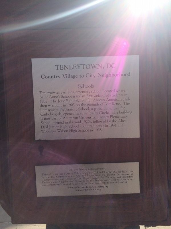
Tenleytown's earliest elementary school, located where Saint Anne's School is today, first welcomed students in 1882. The Jesse Reno School for African-American children was built in 1903 on the grounds of Fort Reno. The Immaculata Preparatory . . . — — Map (db m112531) HM
On Warren Street Northwest at 38th Street Northwest, on the right when traveling east on Warren Street Northwest.
Early Tenleytown homes still standing today were built mostly in the 1890s along paths used by farmers and dairymen. The homes in the Grand Road Historic District (pictured here) are typical of these early dwellings, as are the homes along Belt . . . — — Map (db m112188) HM
On Yuma Street Northwest at 39th Street Northwest, on the right when traveling west on Yuma Street Northwest.
Designated a D.C. Landmark in 1960, the Rest (pictured here) is Tenleytown's oldest residence (built around 1800) and is located at the corner of Windom Place and 39th Street. Local legend maintains that the bricks for the house were brought over . . . — — Map (db m112187) HM
On 37th Street Northwest at Windom Place Northwest on 37th Street Northwest.
The Tenleytown Firehouse (pictured here) dates to 1903. Its location on Wisconsin Avenue near Tenley Circle provides access and coverage to the greater Tenleytown area. Prior to the introduction of motor driven fire vehicles in the 1920s, the . . . — — Map (db m111344) HM
On Wisconsin Avenue Northwest at Upton Street Northwest, on the left when traveling north on Wisconsin Avenue Northwest.
Since the 1700s, Tenleytown has served as a transportation hub, a role that is undiminished today. Tenleytown was strategically located at an early crossroad for travel and trade to Maryland and Virginia. Wisconsin Avenue follows a natural . . . — — Map (db m112174) HM
On Brandywine Street Northwest at 44th Street Northwest, on the right when traveling east on Brandywine Street Northwest.
In the 1700s and 1800s Tenleytown's origin as a crossroad generated numerous commercial activities, such as tobacco trade, farms, dairies, and slaughterhouses, along with the "Tennallytown" Tavern. Murdock Mill Road led from Tenleytown to an early . . . — — Map (db m112178) HM
On 44th Street Northwest at Yuma Street Northwest on 44th Street Northwest.
One of the oldest churches in Tenleytown is the Eldbrooke United Methodist Church located on River Road. This church was founded in 1840 as the Mount Zion Methodist Church. Some of Tenleytown's earliest inhabitants are buried in The Methodist . . . — — Map (db m112176) HM
On Brandywine Street Northwest at 43rd Place Northwest on Brandywine Street Northwest. Reported damaged.
As an early country village, Tenleytown inhabitants held occupations such as farmers, millers, tavern owners and shopkeepers. Since horses provided the primary method of transportation until the early 1900s, blacksmithing was a popular occupation in . . . — — Map (db m112179) HM
On Chesapeake Street Northwest east of Fort Drive Northwest, on the right when traveling east.
Fort Reno is located at the highest elevation in D.C. A city water reservoir was constructed in the 1890s to serve the city's growing population. The red brick water tower (pictured here) was built in 1903 to provide water pressure to the immediate . . . — — Map (db m112184) HM
On Chesapeake Street Northwest west of Nebraska Avenue Northwest, on the left when traveling west.
At an elevation of 410 feet, Fort Reno is located at the highest point in DC. The fort, originally named Fort Pennsylvania, was well situated to provide defense of the Nation's Capital during the Civil War as one of the Circle of Forts (pictured . . . — — Map (db m20628) HM