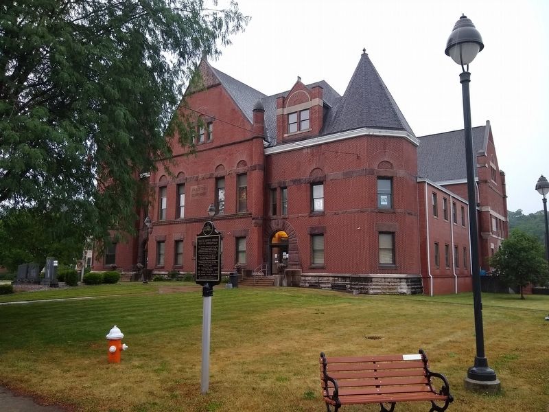
On North Central Avenue at West Court Street, on the left when traveling north on North Central Avenue.
This marker depicts the Fayette County Courthouse as it appeared when built in 1849. Subsequent renovations resulted in its present appearance.
The Courthouse was listed in the National Register of Historic Places in 2006.
Connersville's . . . — — Map (db m152030) HM
On North Central Avenue north of West 4th Street, on the left when traveling north.
(( Center Panel ))
Honoring
all who served
in the United States
Armed Forces
Defending
Liberty and Justice
in All the World
Presented by
Veterans and Citizens
of Fayette County
1986 . . . — — Map (db m44876) WM
On West 18th Street at Western Avenue, on the right when traveling west on West 18th Street.
Lexington Automobiles were produced in Connersville from 1910 to 1926. The Lexington Automobile Company was founded in Lexington, Kentucky, in 1908, but Connersville businessmen enticed the company to move here to replace Connersville's dying . . . — — Map (db m281494) HM
Near Market Street at West Court Street, on the right when traveling north.
Indiana Association of United Ways was the proud sponsor of the statewide Bison-tennial Public Art Project. This legacy project helped celebrate Indiana's 200th birthday by decorating and displaying 5 foot tall fiberglass bison with an end goal . . . — — Map (db m222135) HM
On North Eastern Avenue (Indiana Route 131) at Charles Street, on the left when traveling south on North Eastern Avenue.
John Conner (1775~1826) FOUNDER OF CONNERSVILLE, March 4, 1813; Scout and Indian Interpreter for General William Henry Harrison; Treaty maker for the 12 Mile Purchase 1809; Indiana State Senator 1815 - 1822; First Sheriff of Fayette County 1819; . . . — — Map (db m225342) HM
On Whitewater Memorial State Park Road 0.1 miles west of Route 101, on the right when traveling east.
During World War II, the citizens of Union, Franklin, Wayne and Fayette counties chose to purchase this land and deed it to the Indiana Department of Natural Resources to establish a state park to honor the memory of those who gave their lives in . . . — — Map (db m163197) HM WM
On Long Judson Road (County Road 79) 0.3 miles east of Beaver Creek Road (County Road 203), on the left when traveling east.
The Long-Judson Parker pony truss bridge was designed by R. M. Strohl of Clague and Strohl Company, Bowling Green, Ohio and built by the Elkhart Bridge & Iron Company of Elkhart, Indiana in 1916. It carried Wood County's Township Road 79A . . . — — Map (db m185134) HM
Near Park Road 0.1 miles north of East 28th Street, on the right when traveling north.
Col. James E. Roberts was an industrial leader and prominent citizen of Fayette County. He moved to Connersville during the Civil War era and entered the retail hardware business. In 1874 he purchased interest in a local furniture factory and for . . . — — Map (db m152022) HM
On Fort Boreman Drive 1 mile south of Robert Byrd Highway (U.S. 5).
Parkersburg, (West) Virginia, was first settled permanently in 1785 by Capt. James Neal and other kinfolk and neighbors from Springhill Township, Fayette County, Pa. First chartered by the Virginia Assembly in 1800 as Newport, the town was . . . — — Map (db m73605) HM
On East Cumberland Road (U.S. 40) at South 3rd Street, on the right when traveling east on East Cumberland Road.
Nearly 100 years before Brownstown businesses offered fuel, food, and lodging to motorists following US 40 across America, there was Ezra Griffith and Twin Pumps.
A New York native, Griffith followed the National Road to Fayette County, Ill., . . . — — Map (db m144228) HM
On North Main Street (U.S. 25) at Court Street and Paris Street (Kentucky Route 22), on the left when traveling north on North Main Street.
Formed from Pendleton County in
1820. Named for two brothers who
came from N.C., 1779, established
Grant’s Station, Fayette County.
John developed salt works on the
Licking River. Samuel was killed
by Indians in Indiana in 1794.
William . . . — — Map (db m180614) HM
Near North Main Street (Business U.S. 27) north of Wardlaw Street East, on the right when traveling north.
Named for John Brown
Gordon, a Confederate
general, Georgia governor
and U.S. Senator, this
school stands, as a silent
monument to the citizens
whose legacies made
La Fayette a historically rich
community. Originally
named “Chattooga . . . — — Map (db m142951) HM