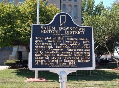
On Public Square (North Side) (State Road 135) at North Main Street, on the left when traveling west on Public Square (North Side).
Washington County Courthouse
County formed 1814 by General Assembly of Indiana Territory. Commissioners selected county seat and named it Salem. This third courthouse completed 1888 using locally quarried limestone. Designed in Richardsonian . . . — — Map (db m46643) HM
On Public Square (South Side) (State Road 135) at South Main Street, on the left when traveling east on Public Square (South Side).
At this point Gen. John Hunt Morgan routed poorly armed militia and occupied Salem - July 10, 1863. The town was looted and $1,000 ransom exacted from each mill owner. — — Map (db m46649) HM
On Public Square (South Side) (State Road 135) at South Main Street, on the left when traveling east on Public Square (South Side). Reported unreadable.
On July 10, 1863 at his headquarters on the southeast side of courthouse square, General Morgan watched the indiscriminate looting of Salem.
Hardest hit was Berkey’s Store on the northwest corner of the square. At Berkey’s more than $1,000 . . . — — Map (db m307359) HM
On Public Square (South Side) east of South Main Street (State Road 135), on the left when traveling east.
The following twenty-one (21) honor roll memorials are arranged as one single ‘marching army in review.’ They are arrayed east to west (starting from the side-walk stairs) in a chronological order (from the American Revolution and ending with . . . — — Map (db m46871) WM
On Federal Lane 0.2 miles east of Tennessee Route 22, on the right when traveling east.
Cyrus Livingston Dunham left a promising political career to serve his country in the Civil War. He resigned his military commission November 18, 1863, his health broken
A Rural Upbringing
Cyrus Dunham was born and raised on a farm . . . — — Map (db m174108) HM
Near South College Street (U.S. 127) at West Lexington Street, on the right when traveling south.
The marriage of Thomas Lincoln and Nancy Hanks took place on the Beechland property of Nancy’s uncle, Richard Berry Sr., in Washington County, about twenty-five miles southwest of here, on June 12, 1806. The ceremony was presided over by the . . . — — Map (db m46317) HM
American Revolutionary War 1775-1783
War of 1812 1812-1815
Mexican-American War 1846-1848
American Civil War April 12, 1861 - April 9, 1865
Spanish-American War April 25 - August 12, 1898
World War I August 1914 - November 11, 1918 . . . — — Map (db m242077) WM
On W Dixie Avenue at N. Mulberry Street (U.S. 62), on the left when traveling east on W Dixie Avenue.
Shortly after Thomas and Nancy Lincoln's wedding in Washington County on June 12, 1806, the couple set up housekeeping in Hardin County where Thomas owned a farm near Elizabethtown on Mill Creek. Nancy gave birth to Lincoln's first child, a daughter . . . — — Map (db m249363) HM
Near Beechland Road (Kentucky Route 438) at Lincoln Park Road ( Route 528), on the left when traveling east.
Thomas Lincoln
Thomas Lincoln was born on January 7, 1778, in Rockingham County, Virginia, to Captain Abraham and Bathsheba Lincoln. He was the youngest of three sons and the fourth of five children. The Lincoln family migrated from . . . — — Map (db m46311) HM
Near East Lincoln Highway Road west of County Road 1300E.
Thomas Lincoln, like most adult white men in the United States, was obliged to serve in his state's militia. In 1795, at the age of seventeen, he served a few months "for the defense of the frontiers of Washington County" Kentucky against Indian . . . — — Map (db m188286) HM
On Tebbs Bend Road 0.3 miles west of New Columbia Road ( Route 55), on the left when traveling west.
Major Edward P. Byrne
Commander of the Confederate Artillery
A native Kentuckian, Byrne was living in Greenville, Washington County, Mississippi, when the war broke out. His first battery of six brass field pieces, their carriages, and . . . — — Map (db m133838) HM
In Late March 1836, the Texian Army was in retreat ahead of Santa Anna's advancing Mexican forces. The retreat spurred the "Runaway Scrape" - a wave of settlers fleeing for their lives. To prevent the enemy from benefitting from San Felipe's . . . — — Map (db m206186) HM
Near Beechland Road (Kentucky Route 438) at Lincoln Park Road ( Route 528), on the left when traveling east.
President Abraham Lincoln’s great, great, great, great grandfather, Samuel Lincoln, left England in 1637, settling in Hingham, Massachusetts. The next four generations of Lincolns continued to move south and west — to New Jersey, then . . . — — Map (db m46301) HM
Near Beechland Road (Kentucky Route 438) at Lincoln Park Road ( Route 528), on the left when traveling east.
The Nancy Hanks Memorial was constructed to honor the mother of President Abraham Lincoln. The native limestone memorial was dedicated on June 12, 1935, the 129th anniversary of the marriage between Thomas Lincoln and Nancy Hanks.
Three young . . . — — Map (db m46263) HM
On Fort Street 0 miles north of Fort Square, on the right when traveling north.
[Marker Front]:
The Lewis and Clark Expedition
Meriwether Lewis arrived in Marietta on September 13, 1803. His descent of the Ohio River aboard a keelboat began his expedition to explore the West. Included among his crew was 18-year . . . — — Map (db m20741) HM
Thin black lines indicate changes in relevance. Between each pair of lines entries are ordered geographically but all have the same relevance.
* Inflectional forms of words are their plurals, singulars, and possessives as well as gramatical tenses and similar variations.