10 entries match your criteria.
Related Historical Markers
To better understand the relationship, study each marker in the order shown.
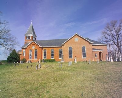
By Tom Fuchs, March 31, 2007
St. Mary’s Church
SHOWN IN SOURCE-SPECIFIED ORDER
| On Olivers Shop Road (Maryland Route 232) 1.2 miles south of Leonardtown Road (Maryland Route 5). |
| On Brandywine Road (Maryland Route 381) 0.1 miles south of Woodyard Road (Maryland Route 223), on the left when traveling south. |
| On Dr. Samuel Mudd Road (Maryland Route 232) south of Poplar Hill Road (Maryland Route 382). |
| On Dr. Samuel Mudd Road (Maryland Route 232) near Poplar Hill Road (Maryland Route 382). |
| On Bel Alton Newton Road at Wills Road, on the right when traveling north on Bel Alton Newton Road. |
| On Bel Alton Newtown Road, on the left when traveling east. |
| Near Bel Alton Newtown Road, 0.1 miles east of Rich Hill Farm Road, on the right when traveling west. |
| On Popes Creek Road, 1.8 miles south of Crain Highway (U.S. 301). |
| On Dahlgren Road (Virginia Route 206) at Cleydael Boulevard, on the right when traveling north on Dahlgren Road. Reported permanently removed. |
| On U.S. 301, 2.5 miles south of U.S. 17, on the right when traveling north. Reported missing. |
Jun. 17, 2024