THE HISTORICAL
MARKER DATABASE
“Bite-Size Bits of Local, National, and Global History”


113 entries match your criteria. Entries 101 through 113 are listed. ⊲ Previous 100                                              


UNESCO World Heritage Sites Historical Markers

United Nations Educational, Scientific and Cultural Organization designated historical sites.
 
By Charles Berman, November 27, 2023
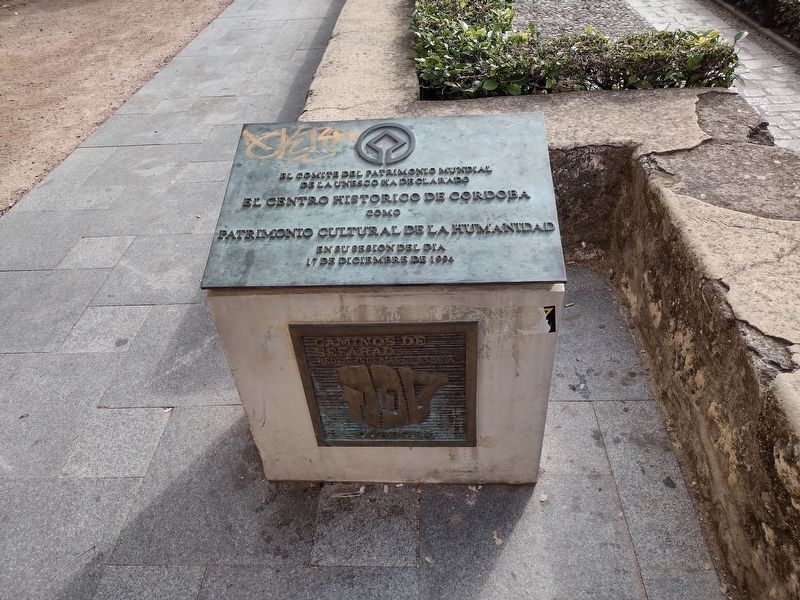
Historic Center of Cordova Marker
101 ► Spain, Andalucía, Córdoba, Huerta del Rey Vallellano — Historic Center of Cordova — UNESCO World Heritage Site —
On Calle Puerta de Almodóvar, on the left when traveling north.
El comite del patrimonio mundial de la UNESCO ha declarado el centro historico de Cordoba como patrimonio cultural de la humanidad en su sesion del dia 17 de diciembre de 1994 (English translation:) The . . . — — Map (db m252830) HM
102 ► Spain, Aragón, Zaragoza, La Almozara — 01 — La Aljafería — 1808 · 1809 Los Sitios de Zaragoza —
On Calle de los Diputados south of Calle de Santa Lucía, on the right when traveling south.
La Aljafería Tras los sucesos del 2 de mayo de 1808 en Madrid, y conforme iban llegando las noticias a todas las capitales españolas, se fueron produciendo motines antifranceses en muchas de ellas. El de Zaragoza fue el 24 de . . . — — Map (db m236721) HM
103 ► United Kingdom, England, County Durham, Durham — Durham Cathedral and Castle —
Near Owengate at Baily Court, on the right when traveling south.
Durham Cathedral and Castle World Heritage Site In Accord with the Principles of the World Heritage Convention Durham Cathedral and Castle have been designated a World Heritage Site One of a number of protected areas of outstanding natural and . . . — — Map (db m122207) HM
104 ► United Kingdom, England, Merseyside, Liverpool — Albion House — Built 1896–1898 —
On James Street east of The Strand, on the left when traveling east.
Designed by Richard Norman Shaw White Star Line Offices — — Map (db m313637) HM
105 ► United Kingdom, England, Merseyside, Liverpool — Corn Exchange — Opened 1808 — World Heritage • Patrimoine Mondial • Patrimonio Mundial —
On Brunswick Street at Fenwick Street, on the left when traveling west on Brunswick Street.
Designed by John Foster Junior The first in England Rebuilt 1953 – 1959 — — Map (db m316165) HM
106 ► United Kingdom, England, Merseyside, Liverpool — High Street — Laid out c1207 —
On High Street north of Dale Street, on the right when traveling north.
One of the original seven streets Formerly Joggler (Juggler) Street Site of weekly market & annual fairs Here its southern end was marked by the High Cross — — Map (db m314025) HM
107 ► United Kingdom, England, Merseyside, Liverpool — India Buildings — Built 1923–1937 —
On Water Street at Covent Garden, on the left when traveling west on Water Street.
Designed by A. Thornely & H. J. Rowse Home of the Alfred Holt & Co Shipping Line The site of the first India Buildings built 1837–1839 — — Map (db m314029) HM
108 ► United Kingdom, England, Merseyside, Liverpool — Queen Insurance Building —
On Dale Street at Exchange Street East, on the left when traveling west on Dale Street.
Built 1837–1839 Queen Insurance Building Designed by Samuel Rowland for the Royal Bank — — Map (db m314024) HM
Paid Advertisement
109 ► United Kingdom, England, Merseyside, Liverpool — Sir Banastre Tarleton MP — 1754 – 1833 —
On Fenwick Street at Water Street, on the right when traveling north on Fenwick Street.
1754 – 1833 Sir Banastre Tarleton MP Major-General Born here — — Map (db m314028) HM
110 ► United Kingdom, England, Merseyside, Liverpool — The Oceanic Navigation Steam Company —
On James Street east of The Strand, on the left when traveling east.
Founded 1869 The Oceanic Navigation Steam Company Founded by T. H. Ismay — — Map (db m313640) HM
111 ► United Kingdom, England, Merseyside, Liverpool — West Africa House — Built 1920 —
On Water Street west of Drury Lane, on the left when traveling west.
Designed by Briggs, Wolstenholme & Thornely Former Bank of British West Africa — — Map (db m314036) HM
112 ► United Kingdom, England, Northumberland, Bardon Mill — Hadrian's Wall — Frontiers of the Roman Empire World Heritage Site —
Near no nearby street.
Hadrian's Wall formed the north-west frontier of the Roman empire for most of the period AD 122-410. The empire's frontiers extended over 5,000 km from the Atlantic coast of Britain through Europe, the Middle East and across North Africa to the . . . — — Map (db m85985) HM
113 ► United Kingdom, Northern Ireland, Causeway Coast and Glens, Bushmills — Hamill Terrace — Causeway Coastal Route —
On Main Street, on the right when traveling south.
Side A Welcome to Hamill Terrace Renowned as the gateway to the Giant's Causeway and for the oldest licensed whiskey distillery in the world, Bushmills has a unique heritage of historic buildings and mills. Images (clockwise . . . — — Map (db m70873) HM

113 entries matched your criteria. Entries 101 through 113 are listed above. ⊲ Previous 100
 
 
CeraNet Cloud Computing sponsors the Historical Marker Database.
This website earns income from purchases you make after using our links to Amazon.com. We appreciate your support.
Paid Advertisement
Nov. 11, 2026
