310 entries match your criteria. Entries 301 through 310 are listed.⊲ Previous 100
Historical Markers and War Memorials
in the West Desert Region
By Dawn Bowen, June 17, 2007
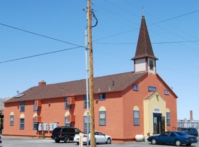
Chapel is now an apartment complex
301 ► Utah, Tooele County, Wendover — Base Chapel —  |
| On Historic Wendover Airfield. | |||
| A community, such as the one created by the military in Wendover, wouldnot have been complete without a base chapel for the spiritual guidance of men and women assigned to the base. Chaplains were needed to assist in the mental and moral . . . — — Map (db m1460) HM | |||
| 302 ► Utah, Tooele County, Wendover — Bomb Squadron Hangar — |
| Near Historic Wendover Airfield. | |||
| You are looking at building #800, a squadron hangar, built of wood from standard plans for an OBH-2. Four of these hangars were built in 1942 and 1943. Each one faces the airport anchorage apron and has ten rolling doors that opened up to . . . — — Map (db m226382) HM | |||
| 303 ► Utah, Tooele County, Wendover — Bonneville Salt Flats International Speedway — |
| On Bonneville Speedway Road near Leppy Pass Road, on the left when traveling east. | |||
| The salt flats were formed as ancient Lake Bonneville slowly evaporated and deposited concentrations of salt onto this playa. Shorelines carved into the mountainsides are visible to the north along the Silver Island range and extend to the Salt Lake . . . — — Map (db m105238) HM | |||
| 304 ► Utah, Tooele County, Wendover — Control Tower — |
| Near Historic Wendover Airfield. | |||
| Standing watch for years, this original tower is a historic landmark for the airport, Working with only radio and runway lighting, air controllers directed the heavy air traffic of the airfield. This tower did not have radar installed during the . . . — — Map (db m1353) HM | |||
| 305 ► Utah, Tooele County, Wendover — First Transcontinental Telephone Line — |
| Near Interstate 80 at milepost 10, on the right when traveling east. | |||
| On June 17, 1914, the first transcontinental telephone line was completed near this point on the border of Nevada and Utah at Wendover. Construction forces of the Bell Telephone Company of Nevada and the Mountain States Telephone and Telegraph . . . — — Map (db m67176) HM | |||
| 306 ► Utah, Tooele County, Wendover — HU-21 — Hastings Cutoff - Barren Mountains — |
| Near Unnamed Road near Leppy Pass Road, on the left when traveling north. | |||
| "The roads were gravelly round the end of some high rocks. Barren mountains (Silver Island)." -- Robert Chalmers, July 27, 1850 — — Map (db m105241) HM | |||
| 307 ► Utah, Tooele County, Wendover — Operations Building — |
| Near Historic Wendover Airfield. | |||
| Welcome to Wendover Airport, the historic airfield where the most heavy bomber crews were trained, including the crews of the Enola Gay and Bock’s Car B-29 bombers that flew the atomic missions over Japan. Twenty-one heavy bomber squadrons and . . . — — Map (db m1330) HM | |||
| 308 ► Utah, Tooele County, Wendover — South Base Area — |
| Near S. Airport Apron south of Airport Way. | |||
| Looking south, there are several bunkers visible which were used to store the munitions used in training. Buildings to the right of the bunkers were used late in the wartime period for the development of the atomic bombs, Little Boy & Fat Man as . . . — — Map (db m71463) HM | |||
| 309 ► Utah, Tooele County, Wendover — The Donner-Reed Party — |
| On Silver Island Road near Crater Island Road, on the right when traveling west. | |||
| passed this way on the 2nd of September 1846, having lost 36 oxen, several wagons, and suffered much. "Don't look for SHORT-CUTS" — — Map (db m105246) HM | |||
| 310 ► Utah, Tooele County, Wendover — Welcome to the Bonneville Salt Flats — And Utah's Famed Measured Mile—Site of World Land-Speed Record Runs — |
| Near Interstate 80 at milepost 10, on the right when traveling east. | |||
| Utah's famed measured mile is located approximately seven miles beyond this marker, well in front of the mountains you see on the horizon. The elevation along that course is approximately 4,218 feet above sea level. *** The total length of the . . . — — Map (db m294817) HM | |||
310 entries matched your criteria. Entries 301 through 310 are listed above. ⊲ Previous 100