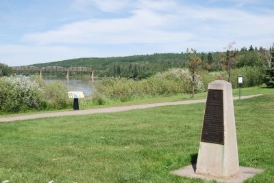
This was once the "jumping off point" for the vast northland. Here in 1887 the first steamboat "Athabasca" was built to ply the river between Mirror Landing and Grand Rapids.
Steamboats superceded the canoe, York boat, and scow, and were . . . — — Map (db m8837) HM
A European food that was brought to Western Canada in the early 19th century by the working and poor people. It originated as a boiled dumpling, and later people added whatever they desired inside, and it became a pyrogy – pyrohy, sometimes called . . . — — Map (db m8813) HM
Lloydminster City Hall is located on the site of the former Meridian School, which was built in 1925. The eastern entrance replicates the original design of the school, re-using the original brick and tyndall stone from the building. R.L. Wilkin . . . — — Map (db m212401) HM
In 1967, Canada’s centennial year, a caravan of motor vehicles travelled from Winnipeg to Vancouver to celebrate the final stages of construction of a new highway through the Rocky Mountains… the Yellowhead. These people were members of the . . . — — Map (db m212400) HM
In A History of Grande Cache, renowned Canadian artist Robert Guest described a typical fur cache. "The cache was made from sturdy logs to withstand the severe winter conditions and the predators such as wolverines and bears, which might try . . . — — Map (db m205223) HM
CNR Water Tank History
Heinsburg became a terminal and turn around point for the Canadian National Railway (CNR) Coronado sub-division in the 1920's after the proposed Heinsburg-Frenchman Butte link was cancelled. A water tank was needed at . . . — — Map (db m197045) HM
In 1897 a rancher drove the first herd of cattle into the Vermilion area, to a site about two miles east of the present day town, but it was only after the region was surveyed in 1902 that significant numbers of settlers from Eastern Canada, . . . — — Map (db m212197) HM
The earliest trade route between eastward and northward flowing waters followed the Clearwater River and the Methye Portage.
Discovered by Peter Pond in 1778 and used continuously for more than a century by fur-traders and explorers, including . . . — — Map (db m8814) HM