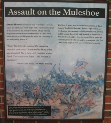
Assault on the Muleshoe Emory Upton's success on May 10 prompted Grant to repeat the attack on a much larger scale. This time the target of the assault was the Muleshoe Salient, a huge outward bulge in the center of the Confederate line. If . . . — — Map (db m10736) HM
No Turning Back Defeated but undeterred, Grant abandoned Spotsylvania's blood-soaked fields on May 21 and continued south -- toward Richmond and ultimate victory. In his wake he left a scarred landscape pitted with thousands of graves.
The . . . — — Map (db m10740) HM
This road leads to the Landram House ruin. In the days of the Civil War it was a small whitewashed dwelling built of squared logs and heated by stone-chimneyed fireplaces. From similar modest homesteads, North and South, had spring Abraham Lincoln . . . — — Map (db m10309) HM
May 12, 1864. Union commanders Grant and Meade determined to exploit the Confederate "Mule Shoe." Early in the morning they sent Hancock's II Corps against the apex of the Salient (300 yards east). Hancock took the trenches on either side of the . . . — — Map (db m10310) HM
May 12, 1864. About 6 a.m. Wright's VI Corps advancing to support Hancock's attack occupied the area in front of the Confederate works on the west face of the Salient. Here at a slight bend in the line, the area ever after known as the Bloody Angle, . . . — — Map (db m10311) HM
(Front): 49th N.Y. Inf'y 3rd Brig. 2d Div. 6th Corps. Held this position May 12, 1864. (Left):The muffled drums sad roll has beat. The soldiers last tattoo. No more on life's parade shall meet that brave and fallen few. On fame's . . . — — Map (db m10312) HM
(Front): 1861-1865 15th Reg't N.J. Vol's. Erected by the State of New Jersey to mark the portion of the Confederate line held by the 14th Georgia Regiment. and assaulted May 12, 1864, by the 15th Regiment New Jersey Volunteer Infantry, . . . — — Map (db m181511) HM
(West Side): Dedicated to the memory of the gallant 126th Reg't O.V.I. commanded by Colonel Benjamin F. Smith and Lieut. Colonel Aaron W. Ebright 2nd Brigade 3rd Division 6th Army Corps. Army of the Potomac (North Side):Ohio's . . . — — Map (db m10314) HM
Over a century has elapsed since the destiny of the nation was debated by arms at Spotsylvania. Many physical changes have altered the appearance of the battlefield during these years including the reclamation of old fields and pastures by an . . . — — Map (db m10315) HM
On May 12, 1864, the pastures, potato patches, and crop-lots of Willis Landram's farm would become North America's most notorious killing field. Just before dawn, 20,000 Union soldiers swarmed past the Landram house toward the main Confederate . . . — — Map (db m10317) HM
The rubble of two chimneys is all that remains of Willis Landram's modest farmhouse, a building destroyed in the 1864 battle. The 65-year-old Landram, his wife Lucy, and five other family members chiseled a life of bare essentials from 170 acres. . . . — — Map (db m10325) HM
These stone chimneys are all that remain of the Landram house, a prominent landmark during the Spotsylvania Campaign. The Confederate picket reserve stood here shivering in the early morning fog on May 12, 1864 when the silence was suddenly . . . — — Map (db m10326) HM
These one hundred and sixty-two acres known as the Landram Farm, were presented to the Fredericksburg and Spotsylvania National Military Park by the Military Order of the Loyal Legion of the United States Commandery of the State of Pennsylvania and . . . — — Map (db m10327) HM
Like most Spotsylvania County residents, Edgar W. Harrison little imagined the impact the Civil War would have on his community and his life. Harrison, his wife Ann, and their three young children lived in a story-and-a-half farmhouse set on the . . . — — Map (db m10424) HM
The General's countenance showed that he had despaired and was ready to die rather than see the defeat of his army. Isaac G. Bradwell, 3rd Georgia Infantry In these fields on the morning of May 12, 1864, Gen. Robert E. Lee faced a crisis . . . — — Map (db m10426) HM
This post-war photograph of the Harrison House and farm was taken from the northwest not far from where the trail crossed the paved road. Lt. Gen. Richard S. Ewell, commanding the Confederates defending the salient, made his headquarters here on the . . . — — Map (db m10284) HM
These well-preserved earthworks which run east and west through the woods are the remains of the defensive position constructed during the fighting at the Bloody Angle. Major General Martin Luther Smith, Lee's chief engineer and designer of the . . . — — Map (db m10283) HM
May 12-13, 1864. This line of earthworks, the remains of which run eastward through the woodland, was built across the base of the Confederate "Mule Shoe" during the Federal attacks against the Salient. As the weary Confederates held their enemies . . . — — Map (db m10278) HM
May 18, 1864. About dawn, Hancock's and Wright's Corps advanced southward past the McCoull House and attacked Ewell's Corps which was holding the new line. They hoped to repeat the Federal success of May 12. This time, however, Confederate cannon . . . — — Map (db m10279) HM
Following the fight for the "Bloody Angle," Lee constructed this new line of works across the base of the Muleshoe. Unwilling to attack the Confederates in their new position, Grant shifted east toward the Fredericksburg Road (modern Route 208). . . . — — Map (db m10281) HM
The gentle mounds that meander through Spotsylvania Court House battlefield once looked like the reconstructed earthwork in front of you. The armies built more than 12 miles of trenches here, using whatever tools they could find. Lee's last line, . . . — — Map (db m10282) HM
2nd North Carolina State Troops Col. William R. Cox 4th North Carolina State Troops Col. Bryan Grimes 14th North Carolina Troops Col. R. Tyler Bennett 30th North Carolina Troops Col. Francis M. Parker At dawn May 12, 1864 Union troops . . . — — Map (db m10286) HM WM
Surrounded on all sides by low ridge lines, Neil MccCoull's house sat in the center of the famous Muleshoe Salient. On the night of May 8, 1864, Confederate engineers built the bulging line of earthworks that wrapped around McCoull's farm to the . . . — — Map (db m10289) HM
This was the home of farmer Neil McCoull and his unmarried sisters Mary, Eliza, and Milly. McCoull's farm was typical of those that dotted Spotsylvania County: a few hundred acres that produced a modest income from corn and other grains. Like his . . . — — Map (db m10290) HM
This spring has always been important to the McCoull family but on May 12, 1864 it became a vital source of rejuvenation to hundreds of Confederates involved in the fighting at the Bloody Angle. Colonel Charles S. Venable, an aide-de-camp to Lee, . . . — — Map (db m10291) HM
May 12, 1864. From this point the trenches of the Confederate Salient run southward. This road continues westward along a secondary line which was held by Gordon's Division. Gordon's line tied into the east face of the Salient here, where Ewell's . . . — — Map (db m10427) HM
May 12, 1864. About 4:30 a.m. Hancock's Federal II Corps, in one of the greatest surprise attacks of the War, struck Ewell's Confederate Corps entrenched here. Advancing in a solid rectangular mass, the Federal troops overwhelmed the defenders. The . . . — — Map (db m10397) HM
May 12, 1864. In the large scale attack of this day, Warren's V Corps on the Federal right and Burnside's IX on the left engaged the Confederate forces facing them while Wright's VI moved to help Hancock. The seriousness of Lee's counterattack . . . — — Map (db m10403) HM
After four days of probing attacks, Gen. Ulysses S. Grant ordered a frontal assault against the Confederate lines at Spotsylvania Court House on 12 May 1864. The focal point of the attack was the Muleshoe Salient, an outward bulge in the . . . — — Map (db m8915) HM
May 12, 1864. Burnside's IX Corps, having swung east in its march from the Wilderness, engaged the Confederates by way of the Fredericksburg-Spotsylvania Road and held the Federal left in this area. On the morning of May 12 Burnside was ordered to . . . — — Map (db m10429) HM