THE HISTORICAL
MARKER DATABASE
“Bite-Size Bits of Local, National, and Global History”


3 entries match your criteria.  


Related Historical Markers

Indian Boundary Line markers in Chicagoland
 
October 5, 2012
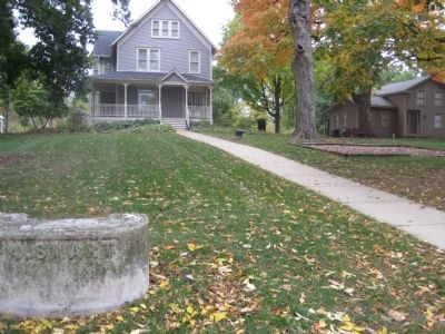
The Indian Boundary Line is in front of the Downers Grove Park District Museum
SHOWN IN SOURCE-SPECIFIED ORDER
1 ► Illinois, DuPage County, Downers Grove — The Indian Boundary Line —
Immediately north of this marker runs the Indian Boundary Line which was established on Aug 24, 1816 by a treaty between three U.S. commissioners and the Chippewa, Ottawa and Potawotami Indians to provide a corridor between Lake Michigan and the . . . — — Map (db m60035) HM
2 ► Illinois, Cook County, Chicago, West Ridge — Indian Boundary Village —
Long ago, Native American Indians lived on this land. Before recorded history, the Mound Builders traveled the area, perhaps along the nearby Ridge. Later the Illinois Tribe hunted game and planted maize. Last it was the Ottawa, the Chippewa, and . . . — — Map (db m68560) HM
3 ► Illinois, Cook County, Chicago, Rogers Park — Indian Boundary Lines —
Clark Street honors George Rogers Clark, whose brother, William Clark, with Ninian Edwards and Auguste Chouteau, in 1816 negotiated Indian treaty ceding land including Chicago site from Rogers Avenue to Lake Calumet.
Authenticated by . . . — — Map (db m242836) HM


CeraNet Cloud Computing sponsors the Historical Marker Database.
This website earns income from purchases you make after using our links to Amazon.com. We appreciate your support.
Paid Advertisement
Sep. 30, 2026
