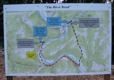
You are standing less than a mile from an important battle site in the Civil War. Just ahead a handful of determined Union troops and townspeople would thwart the Confederate Raiders. Though small in scale compared to Gettysburg and Antietam, the . . . — — Map (db m253598) HM
Hills Headquarters
"Rowlesburg, the headquaters of General Hill in Western Virginia, is situated in a deep gorge in the Alleghenies, at a point where the Baltimore and Ohio Railroad crosses Cheat River. The scenery around it is bold, grand, and . . . — — Map (db m256096) HM
A howitzer (as illustrated above by Peter W. Gaut) is a short-barreled, large-caliber cannon designed to throw shells at a higher trajectory than regular field guns. This makes them useful against enemy troops behind fortifications or concealed . . . — — Map (db m198732) HM
The hilltop area located above and to the right of where you are standing is Cannon Hill. In April 1863, the cannons located there defended Rowlesburg and the Baltimore and Ohio Railroad during a Civil War skirmish. The B&O Railroad crossed the . . . — — Map (db m34041) HM
To S on B&O Railroad is Buckeye Run Viaduct, 136' high, 350' long & 28' wide. Tray Run Viaduct, .6 mi. NW is 148' high, 445' long and 28' wide. Noted engineers Benjamin Latrobe & Albert Fink designed the viaducts. Built 1852 to carry main line, the . . . — — Map (db m33983) HM
Hills Headquarters
"Rowlesburg, the headquaters of General Hill in Western Virginia, is situated in a deep gorge in the Alleghenies, at a point where the Baltimore and Ohio Railroad crosses Cheat River. The scenery around it is bold, grand, and . . . — — Map (db m199725) HM