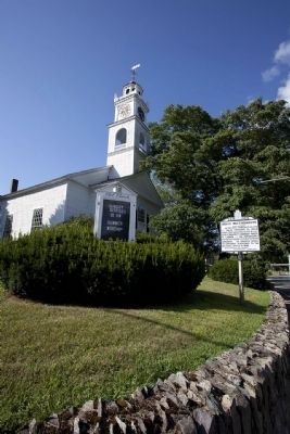
On this site John Eliot helped his Indian converts to build their first meetinghouse in 1651, with a "prophet's chamber" where he lodged on his fortnightly visits to preach to them in their language. His disciple Daniel Takawambait succeeded to . . . — — Map (db m295847) HM
Before colonial times, Native Americans would have seen creeks and wetlands here in Quincy Bay, which provided them with abundant sources of food: shellfish, fish, waterfowl, and migratory birds — even whales. They lived here during spring and . . . — — Map (db m308383) HM
People have lived in the Roxbury area since the last glaciers melted 14,000 years ago. As the climate warmed, glacial melt flooded rivers and coasts, creating a diverse ecosystem. Forests and waters supported abundant game, fish, and shellfish, as . . . — — Map (db m295836) HM
On this hill the Puritans in Roxbury built their first meetinghouse in 1632. The hill was named in 1848 for Reverend John Eliot (1604-1690), the second minister of the First Church in Roxbury. Eliot, known as the ‘Apostle to the Indians’, with the . . . — — Map (db m295839) HM
John Eliot established here in 1651 a village of Christian Indians called Hassanamesit - "at a place of small stones." It was the home of James the Printer who helped Eliot to print the Indian Bible. — — Map (db m295848) HM
The Praying Indian village of Okammakemesit, began by famed “missionary to
the Indians” John Eliot, sat atop Prospect Hill.
From 1654 to his death in 1674, Chief Onamog was the village leader. The Superintendent of Indian Affairs wrote of him, . . . — — Map (db m295849) HM
On this hill the Puritans in Roxbury built their first meetinghouse in 1632. The hill was named in 1848 for Reverend John Eliot (1604-1690), the second minister of the First Church in Roxbury. Eliot, known as the ‘Apostle to the Indians’, with the . . . — — Map (db m257186) HM
PONKAPOAG
For thousands of years this land has been inhabited
inhabited by the Massachusett Tribe.
Their seat of power was at the nearby mountain called massa-adchu-es-et (now
Great Blue Hill). They called this area Ponkapoag (today Canton, . . . — — Map (db m308307) HM