Near Morgantown in Monongalia County, West Virginia — The American South (Appalachia)
Remnants of the Past: The Dam and Outlet Tower
Interpreting History
Photographed by Bradley Owen, December 24, 2023
1. Remnants of the Past: The Dam and Outlet Tower Marker
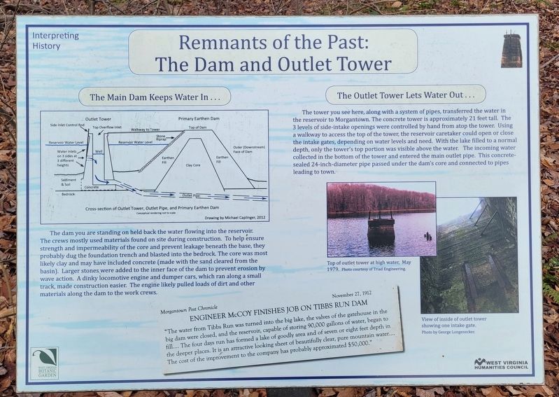
The Main Dam Keeps Water In…
The dam you are standing on held back the water flowing into the reservoir. The crews mostly used materials found on site during construction. To help ensure strength and impermeability of the core and prevent leakage beneath the base, they probably dug the foundation trench and blasted into the bedrock. The core was most likely clay and may have included concrete (made with the sand cleared from the basin). Larger stones were added to the inner face of the dam to prevent erosion by wave action. A dinky locomotive engine and dumper cars, which ran along a small track, made construction easier. The engine likely pulled loads of dirt and other materials along the dam to the work crews.
The Outlet Tower Lets Water Out…
The tower you see here, along with a system of pipes, transferred the water in the reservoir to Morgantown. The concrete tower is approximately 21 feet tall. The 3 levels of side intake openings were controlled by hand from atop the tower. Using a walkway to access the top of the tower, the reservoir caretaker could open or close the intake gates, depending on water levels
this page online
[Inset:]
Morgantown Post Chronicle November 27, 1912
Engineer McCoy Finishes Job on Tibbs Run Dam
"The water from Tibbs Run was turned into the big lake, the valves of the gatehouse in the big dam were closed, and the reservoir, capable of storing 90,000 gallons of water, began to fill.... The four days run has formed a lake of goodly area and of seven or eight feet depth in the deeper places. It is an attractive looking sheet of beautifully clear, pure mountain water.... The cost of the improvement to the company has probably approximated $50,000."
Erected 2014 by West Virginia Botanic Garden and West Virginia Humanities Council.
Topics. This historical marker is listed in these topic lists: Charity & Public Work • Industry & Commerce • Parks & Recreational Areas • Waterways & Vessels. A significant historical year for this entry is 1912.
Location. This marker has been replaced by another marker nearby.
Photographed by Bradley Owen, May 13, 2021
2. Remnants of the Past: The Dam and Outlet Tower Marker
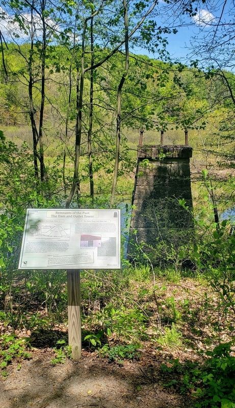
The remains of the outlet tower are seen behind the marker.

Regionally, this marker was in North Central West Virginia. It was also in the American South, specifically in the Upper South, in Appalachia, and specifically in Northern Appalachia. Globally, it was in North America, the Western Hemisphere, the Western World, and the Anglosphere. Historically, it found itself in what was once the territory of the Mississippian Culture.
Other nearby markers. At least 8 other markers are within walking distance of this location: Building the Basin (within shouting distance of this marker); Modernism and Mastery: Lazzell's Paris Influence & the White-Line Woodcut (about 300 feet away, measured in a direct line); How the Reservoir Worked (about 400 feet away); The WVBG Labyrinth (about 500 feet away); The Dam and the Bowl (about 500 feet away); Clean Mountain Water? (about 600 feet away); Prehistoric Garden (about 700 feet away); From Water Resource to Public Garden (approx. 0.2 miles away). Touch for a list and map of all markers in Morgantown.
Other markers no longer nearby. Strong Men and Horses Build the Basin (was about 500 feet away but has been replaced with another marker now near it); The Tibbs Run Reservoir: Then a Water Source, Now a Local Treasure (was about 800 feet away but has been replaced with another marker now near it); Who Wants Clean Water? (was approx. 0.2 miles away but has been replaced with another marker now near it).
Regarding Remnants of the Past: The Dam and Outlet Tower. The marker includes a cross-section of the Outlet Tower, Outlet Pipe, and Primary Earthen Dam, a conceptual rendering not to scale. Drawing by Michael Caplinger, 2012.
Related marker. Click here for another marker that is related to this marker. This marker has been replaced by the linked marker.
Credits. This page was last revised on September 30, 2026. It was originally submitted on May 30, 2021, by Bradley Owen of Morgantown, West Virginia. This page has been viewed 325 times since then and 34 times this year. Photos: 1. submitted on December 24, 2023, by Bradley Owen of Morgantown, West Virginia. 2. submitted on May 30, 2021, by Bradley Owen of Morgantown, West Virginia. • Devry Becker Jones was the editor who published this page.
